Ridge to reef connections: Effects of invasive mangrove removal on nearshore coral reef environment


Figure 1. The Heʻeia ahupuaʻa is located on the windward side of Oʻahu, with the watershed draining into Kāneʻohe Bay, the largest sheltered body of water in the main Hawaiian Islands.
The Heʻeia ahupuaʻa is the most recent addition to the National Estuarine Research Reserve System (NERRS), presenting a unique opportunity to integrate marine, freshwater, fishpond, and terrestrial research to allow for an ecosystem approach in understanding and managing the entire ahupua‘a. This ongoing study investigates the effects of continuing restoration efforts within the ahupuaʻa of Heʻeia and their potential impacts to the adjacent fringing coral reef and associated biota. Currently, extensive removal of the invasive alien red mangrove, Rhizophora mangle, is underway. With rapid changes occurring in the watershed, nutrient and sediment influx are expected to change on the adjacent reef and affect the coral reef community composition. Preliminary results indicate increases in sediment depth at the Heʻeia stream mouth, and provide baseline data to assess long-term changes on the coral reef.
Figure 2. Photographs of the Heʻeia fishpond and watershed in 1928 and 2017. Urbanization and the introduction of alien invasive species has dramatically changed this ecosystem over recent decades.

Figure 3. Monitoring site locations across the lowland Heʻeia ahupuaʻa. While this project focuses on the marine environment, we are working in coordination with several other site partners monitoring the stream and terrestrial environment to understand and sustainably manage this watershed from ridge to reef.
Overview
Figure 1. The Heʻeia ahupuaʻa is located on the windward side of Oʻahu, with the watershed draining into Kāneʻohe Bay, the largest sheltered body of water in the main Hawaiian Islands.
The Heʻeia ahupuaʻa is the most recent addition to the National Estuarine Research Reserve System (NERRS), presenting a unique opportunity to integrate marine, freshwater, fishpond, and terrestrial research to allow for an ecosystem approach in understanding and managing the entire ahupua‘a. This ongoing study investigates the effects of continuing restoration efforts within the ahupuaʻa of Heʻeia and their potential impacts to the adjacent fringing coral reef and associated biota. Currently, extensive removal of the invasive alien red mangrove, Rhizophora mangle, is underway. With rapid changes occurring in the watershed, nutrient and sediment influx are expected to change on the adjacent reef and affect the coral reef community composition. Preliminary results indicate increases in sediment depth at the Heʻeia stream mouth, and provide baseline data to assess long-term changes on the coral reef.
Figure 2. Photographs of the Heʻeia fishpond and watershed in 1928 and 2017. Urbanization and the introduction of alien invasive species has dramatically changed this ecosystem over recent decades.
Figure 3. Monitoring site locations across the lowland Heʻeia ahupuaʻa. While this project focuses on the marine environment, we are working in coordination with several other site partners monitoring the stream and terrestrial environment to understand and sustainably manage this watershed from ridge to reef.
•Quarterly reef monitoring at 24 permanent stations
•Quarterly stream mouth monitoring: gradients in sediment depth, nutrients, and water clarity
•Monitoring and sampling procedures in coordination with reserve partners (e.g., The Nature Conservancy, UH SOEST, Kākoʻo ʻŌiwi, and Paepae o Heʻeia)
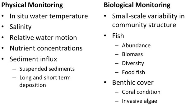

Figure 7. One of the 24 permanent transect stations located on the Heʻeia reef. Stations house an in situ temperature logger within hollow bricks. Sediment traps and clod cards are deployed at these stations quarterly to measure 24-hr sediment accumulation and water motion.

Figure 8. Photos of the benthos are taken every meter along a 25m transect quarterly. Twenty-five random points are projected onto each photo in CoralNet for identification of species or substrate to estimate overall benthic cover.
Methods
•Quarterly reef monitoring at 24 permanent stations
•Quarterly stream mouth monitoring: gradients in sediment depth, nutrients, and water clarity
•Monitoring and sampling procedures in coordination with reserve partners (e.g., The Nature Conservancy, UH SOEST, Kākoʻo ʻŌiwi, and Paepae o Heʻeia)
Figure 7. One of the 24 permanent transect stations located on the Heʻeia reef. Stations house an in situ temperature logger within hollow bricks. Sediment traps and clod cards are deployed at these stations quarterly to measure 24-hr sediment accumulation and water motion.
Figure 8. Photos of the benthos are taken every meter along a 25m transect quarterly. Twenty-five random points are projected onto each photo in CoralNet for identification of species or substrate to estimate overall benthic cover.

Figure 9. (a) Predominant current pattern on the Heʻeia fringing reef measured by drogue survey on an incoming tide. (b) Grain size fractions from sediment samples collected at the 24 permanent monitoring sites in summer 2017. Grain sizes give insight into water flow and long-term sedimentation.

Figure 10. Sediment depth (cm) along four 100m transects fanning out from Heʻeia stream mouth. A substantial increase in sediment depth was observed over the course of intensive mangrove removal in winter 2017 on the southern two transects. Material exiting the stream is likely carried southward by prevailing currents and accumulating faster closer to the fishpond wall. Continued monitoring will help tease apart seasonal fluctuations from potential effects of the restoration process.
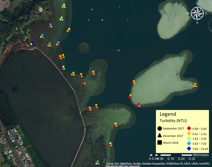
Figure 11. Turbidity (NTU) at 24 permanent monitoring stations sampled one day in September 2017, December 2017, and March 2018.
Physical Monitoring
Figure 9. (a) Predominant current pattern on the Heʻeia fringing reef measured by drogue survey on an incoming tide. (b) Grain size fractions from sediment samples collected at the 24 permanent monitoring sites in summer 2017. Grain sizes give insight into water flow and long-term sedimentation.
Figure 10. Sediment depth (cm) along four 100m transects fanning out from Heʻeia stream mouth. A substantial increase in sediment depth was observed over the course of intensive mangrove removal in winter 2017 on the southern two transects. Material exiting the stream is likely carried southward by prevailing currents and accumulating faster closer to the fishpond wall. Continued monitoring will help tease apart seasonal fluctuations from potential effects of the restoration process.
Figure 11. Turbidity (NTU) at 24 permanent monitoring stations sampled one day in September 2017, December 2017, and March 2018.

Figure 12. Fish biomass at 24 permanent monitoring stations sampled once each in September 2017, December 2017, and March 2018.
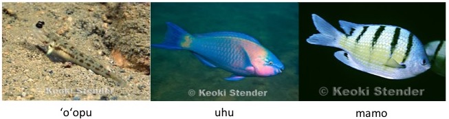
Figure 13. Three of the most abundant fish species on the Heʻeia fringing reef and adjacent patch reef across September, December, and March surveys.
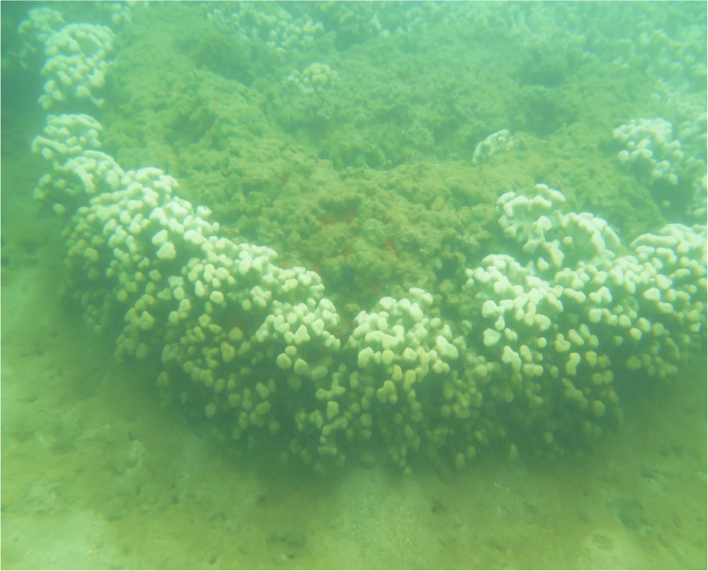
Figure 14. Coral bleaching on the Heʻeia reef flat likely due to a large pulse of freshwater during heavy rainfall in March, 2018. Long-term monitoring of the physical environment and reef condition will broaden our understanding of both natural and anthropogenic impacts to the coral reef.
The Heʻeia reef ranges from nearly 95% coral cover at the reef edge to sand and algae on the inner reef flat. Gradients in temperature, salinity, sedimentation, nutrients, and water motion may elucidate the observed differences in benthic cover across the Heʻeia reef environment.
Biological Monitoring
Figure 12. Fish biomass at 24 permanent monitoring stations sampled once each in September 2017, December 2017, and March 2018.
Figure 13. Three of the most abundant fish species on the Heʻeia fringing reef and adjacent patch reef across September, December, and March surveys.
Figure 14. Coral bleaching on the Heʻeia reef flat likely due to a large pulse of freshwater during heavy rainfall in March, 2018. Long-term monitoring of the physical environment and reef condition will broaden our understanding of both natural and anthropogenic impacts to the coral reef.
The Heʻeia reef ranges from nearly 95% coral cover at the reef edge to sand and algae on the inner reef flat. Gradients in temperature, salinity, sedimentation, nutrients, and water motion may elucidate the observed differences in benthic cover across the Heʻeia reef environment.
1. How does invasive mangrove removal influence adjacent coral reef habitat and associated biota?
2. How does mangrove removal influence sediment transport onto adjacent coral reef habitat during storm runoff events?

Figure 4. The role of mangroves in their native range. Mangroves provide many ecosystem services in their native habitat that are not observed in Hawaiʻi.

Figure 5. Alien invasive mangroves may provide habitat that favors other alien species over Hawaiian native species.

Figure 6. One of the mākāhā at Heʻeia fishpond nearly underwater in March, 2018. Large pulses in stream flow occur frequently in winter months with heavy rains.
Study Questions
1. How does invasive mangrove removal influence adjacent coral reef habitat and associated biota?
2. How does mangrove removal influence sediment transport onto adjacent coral reef habitat during storm runoff events?
Figure 4. The role of mangroves in their native range. Mangroves provide many ecosystem services in their native habitat that are not observed in Hawaiʻi.
Figure 5. Alien invasive mangroves may provide habitat that favors other alien species over Hawaiian native species.
Figure 6. One of the mākāhā at Heʻeia fishpond nearly underwater in March, 2018. Large pulses in stream flow occur frequently in winter months with heavy rains.
Through this collaborative work, we will build a resilient and sustainably managed ecosystem where human and natural communities thrive.
•Integration of traditional ecological knowledge and contemporary research and monitoring strategies
•Potential changes to the physical environment over the course of restoration may influence the biological environment
•Coordinated efforts across the ahupuaʻa allow for a greater understanding of land to sea connections
