HICEAS 2017. A Six Month Ship-Survey of the Hawaiian Archipelago with a Focus on Whales, Dolphins, and Seabirds
Kymberly M. Yano, Erin M. Oleson, Jeffrey E. Moore, Lisa T. Ballance, and Jennifer L. Keating

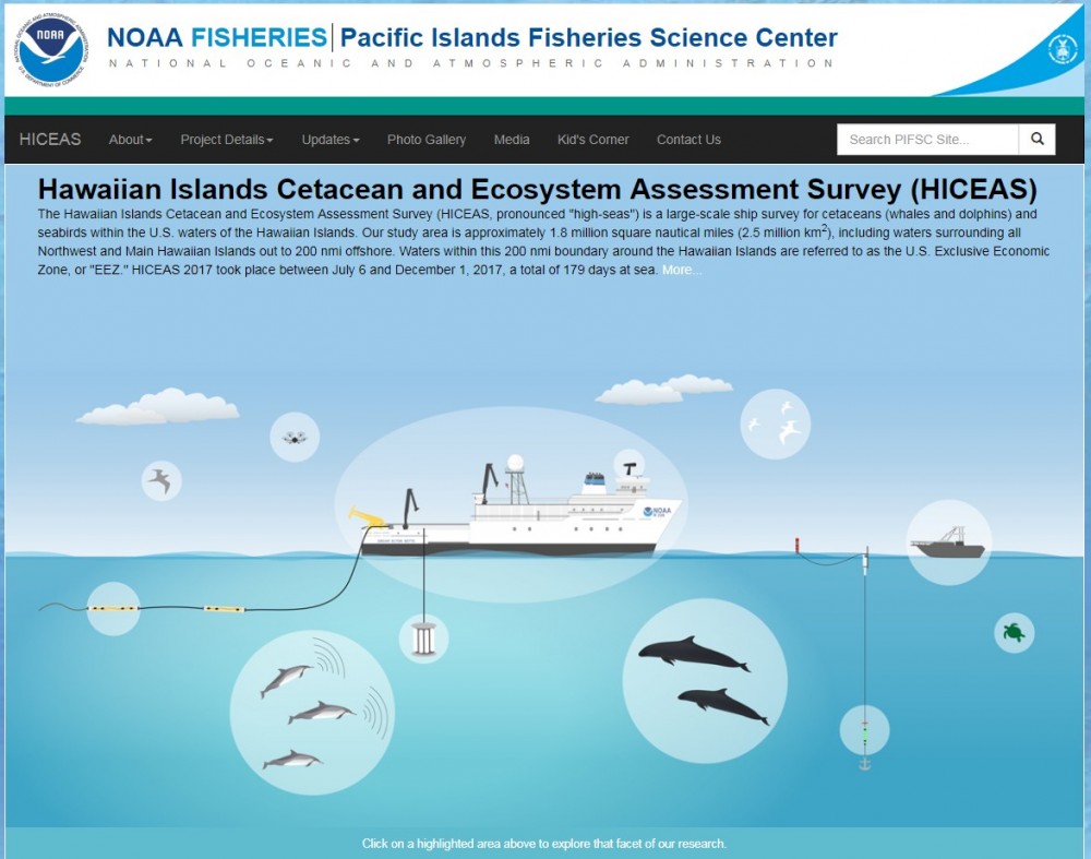
The Hawaiian Islands Cetacean and Ecosystem Assessment Survey (HICEAS, pronounced “high-seas”) is a large-scale ship survey project for cetaceans (whales and dolphins) and seabirds within the U.S. waters of the Hawaiian Islands, including areas around the Northwest and Main Hawaiian Islands out to 200 nmi offshore (this area is referred to as the U.S. Exclusive Economic Zone, or "EEZ"). HICEAS was conducted by the Pacific Islands and Southwest Fisheries Science Centers. NOAA Fisheries conducted HICEAS in 2002, 2010, and 2017.
The goals of HICEAS are to estimate how many cetaceans are in Hawaiian waters, examine their population structure, and understand their habitat. HICEAS 2017 was also the start of a new multi-agency plan called Pacific Marine Assessment Program for Protected Species (PacMAPPS). PacMAPPS is a partnership among NOAA Fisheries, Bureau of Ocean Energy Management, U.S. Navy, and the U.S. Fish and Wildlife Service to collect data and produce abundance estimates for species of joint management interest. PacMAPPS includes rotational surveys throughout the Pacific to assess the abundance of cetacean species and their ecosystems.
Four primary research components:
- Visual observations for cetaceans, including photo-identification, biopsy sampling, and satellite tagging.
- Passive acoustic monitoring using towed hydrophone arrays.
- Ecosystem assessment, including visual surveys for seabirds and measurement of oceanographic variables.
- Ancillary projects, such as aerial photogrammetry using a hexacopter, testing new passive acoustic tools, and other projects that support and augment our assessment mission.
HICEAS 2017 Website
Project Details
The Hawaiian Islands Cetacean and Ecosystem Assessment Survey (HICEAS, pronounced “high-seas”) is a large-scale ship survey project for cetaceans (whales and dolphins) and seabirds within the U.S. waters of the Hawaiian Islands, including areas around the Northwest and Main Hawaiian Islands out to 200 nmi offshore (this area is referred to as the U.S. Exclusive Economic Zone, or "EEZ"). HICEAS was conducted by the Pacific Islands and Southwest Fisheries Science Centers. NOAA Fisheries conducted HICEAS in 2002, 2010, and 2017.
The goals of HICEAS are to estimate how many cetaceans are in Hawaiian waters, examine their population structure, and understand their habitat. HICEAS 2017 was also the start of a new multi-agency plan called Pacific Marine Assessment Program for Protected Species (PacMAPPS). PacMAPPS is a partnership among NOAA Fisheries, Bureau of Ocean Energy Management, U.S. Navy, and the U.S. Fish and Wildlife Service to collect data and produce abundance estimates for species of joint management interest. PacMAPPS includes rotational surveys throughout the Pacific to assess the abundance of cetacean species and their ecosystems.
Four primary research components:
- Visual observations for cetaceans, including photo-identification, biopsy sampling, and satellite tagging.
- Passive acoustic monitoring using towed hydrophone arrays.
- Ecosystem assessment, including visual surveys for seabirds and measurement of oceanographic variables.
- Ancillary projects, such as aerial photogrammetry using a hexacopter, testing new passive acoustic tools, and other projects that support and augment our assessment mission.
HICEAS 2017 Website
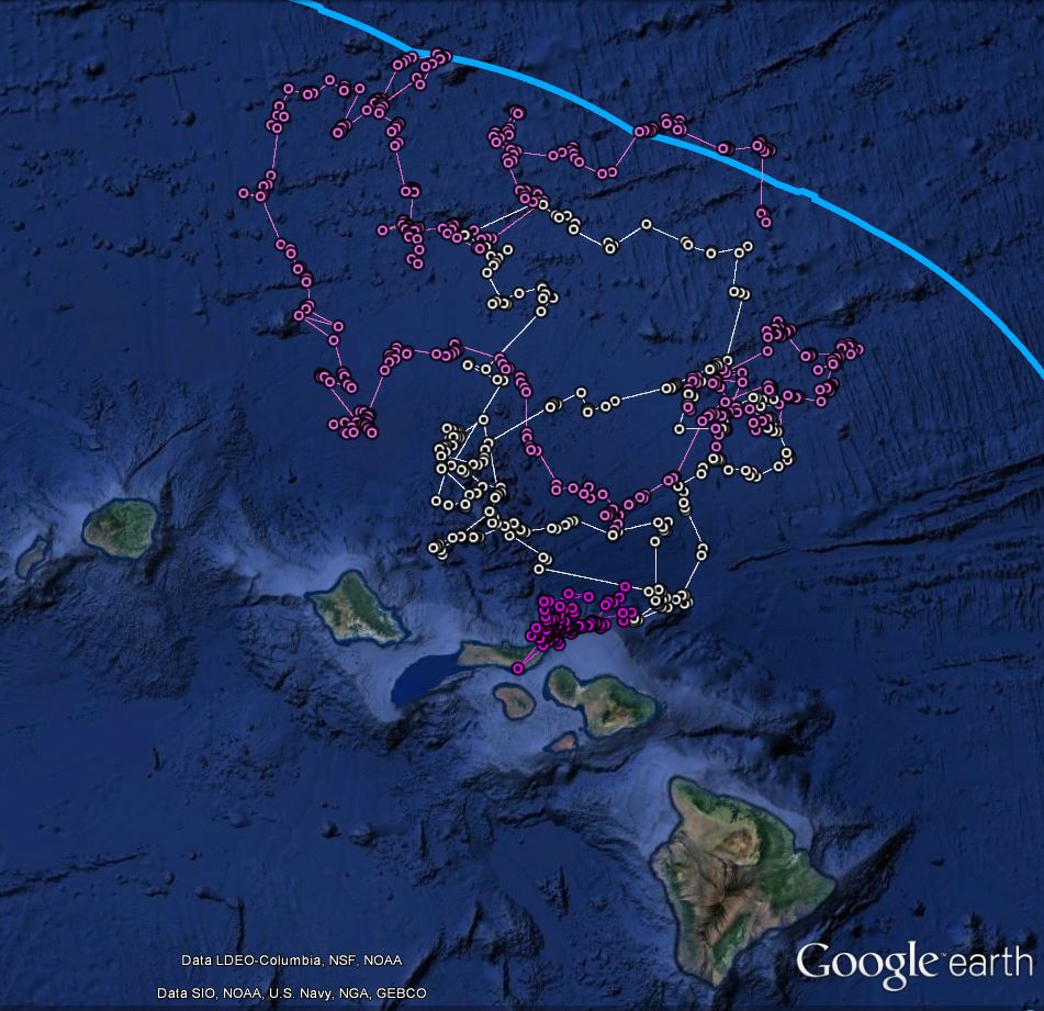
The NOAA Science on a Sphere animation shows the daytime, on-effort trackline of both research vessels in addition to the first cetacean species sighted on a particular day.
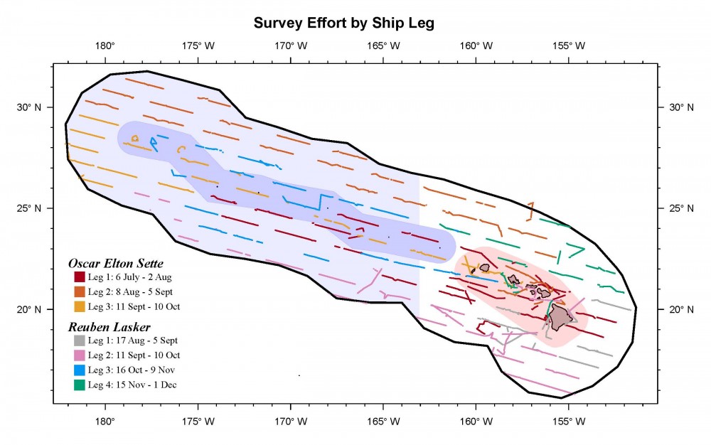
Daytime sighting effort within the Hawai‘i EEZ (black outline), including seven ship legs aboard two NOAA ships.
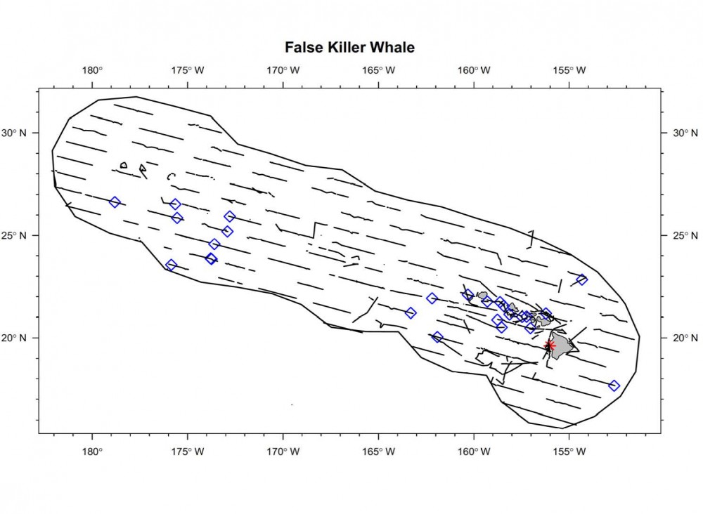
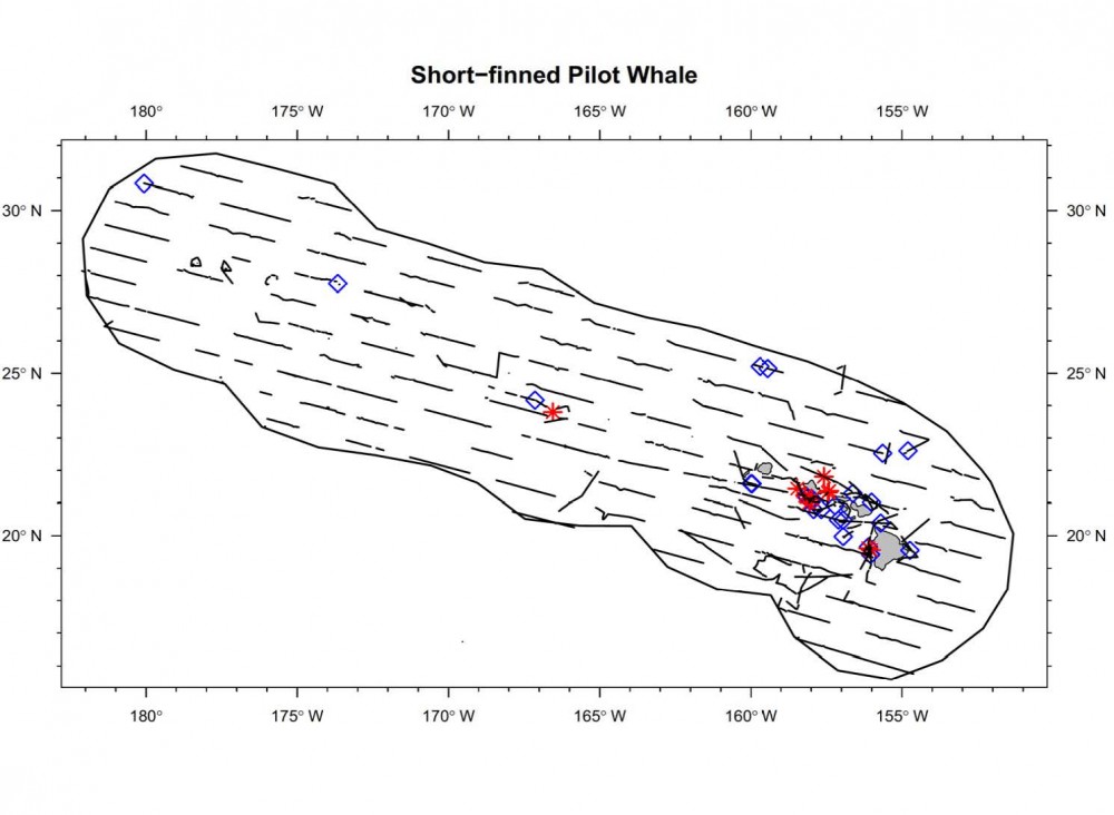
Cetaceans
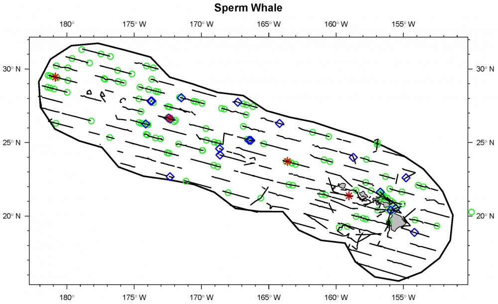
Summary of cetacean species recorded within the Hawai‘i EEZ, with >10 group encounters during HICEAS. Species seen as part of mixed species groups are counted once for each species.
| Common Name | Total Groups | |
| Short-finned pilot whale | 35 | |
| Striped dolphin | 27 | |
| False killer whale | 27 | |
| Pantropical spotted dolphin | 25 | |
| Rough-toothed dolphin | 25 | |
| Sperm whale | 24 | |
| Unidentified beaked whale | 24 | |
| Unidentified small dolphin | 20 | |
| Unidentified dolphin | 18 | |
| Risso's dolphin | 12 | |
| Cuvier's beaked whale | 11 |
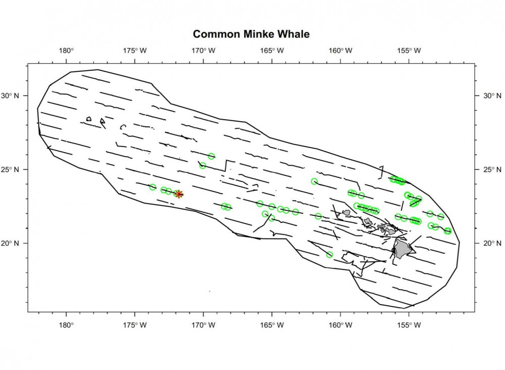
Select Sighting and Distribution Maps
Seabirds
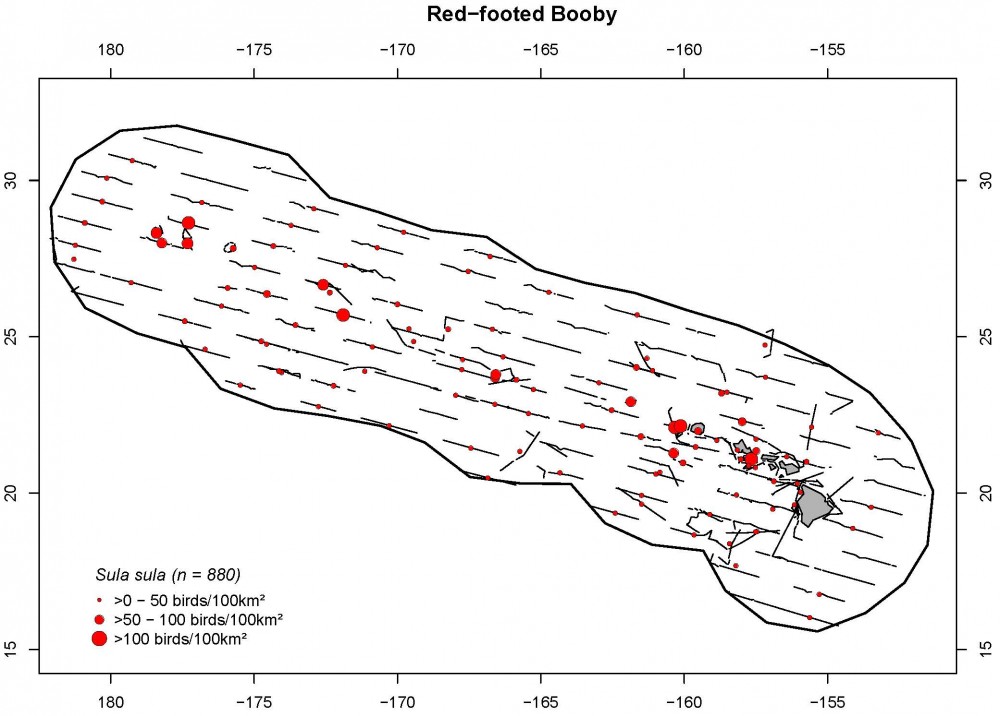
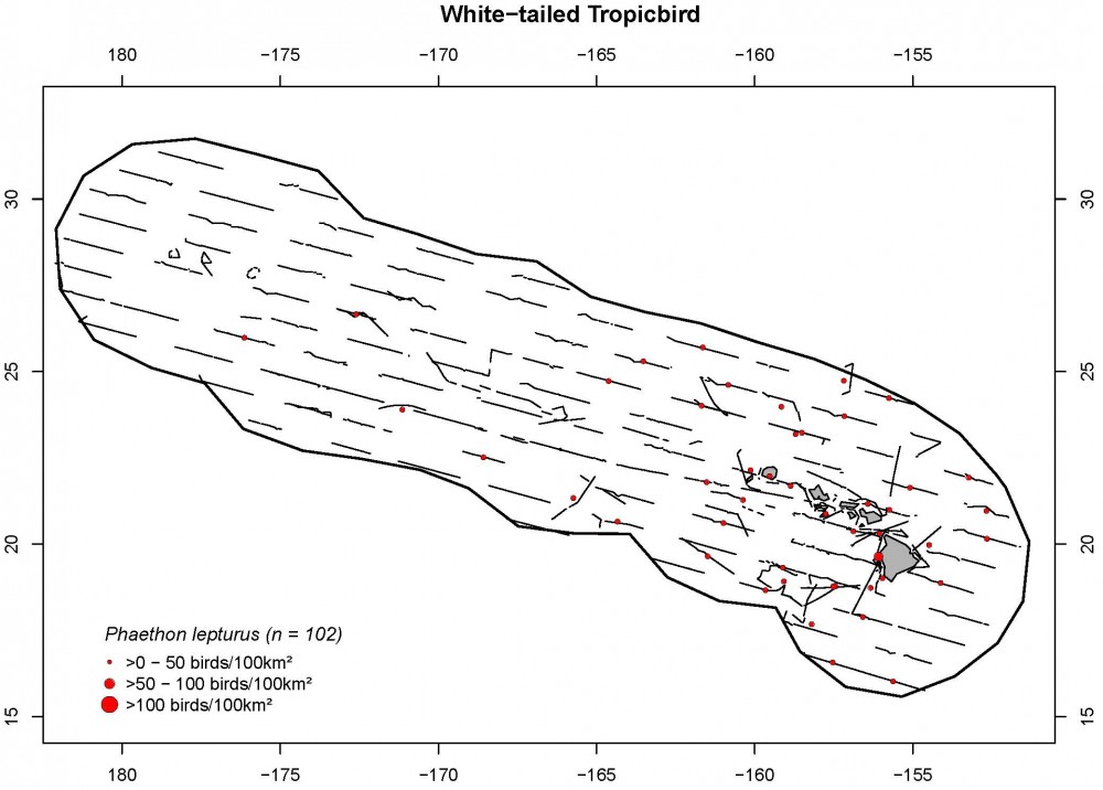
Summary of seabird encounters recorded in the Hawai‘i EEZ with >100 individuals, in descending order of total number of individuals.
| Common Name | Encounters | Individuals |
| Wedge-tailed shearwater (light morph) | 2619 | 5300 |
| Slender-billed (Short-tailed) shearwater | 166 | 2720 |
| Wedge-tailed shearwater (dark morph) | 687 | 2609 |
| Sooty tern | 717 | 2292 |
| Bonin petrel | 1134 | 1673 |
| Black-winged petrel | 799 | 909 |
| Red-footed booby | 521 | 894 |
| Bulwer's petrel | 512 | 578 |
| White tern | 405 | 538 |
| Brown noddy | 130 | 407 |
| Wedge-tailed shearwater | 7 | 345 |
| Great frigatebird | 104 | 319 |
| Black noddy | 94 | 301 |
| Hawaiian petrel | 220 | 248 |
| White-necked petrel | 134 | 211 |
| Brown booby | 142 | 175 |
| Sooty shearwater | 108 | 168 |
| Juan Fernandez petrel | 141 | 162 |
| Shorebird | 105 | 162 |
| Wedge-tailed shearwater (intermediate morph) | 119 | 152 |
| Red-tailed tropicbird | 112 | 124 |
| White-tailed tropicbird | 111 | 121 |
| Black-footed albatross | 99 | 103 |
| Christmas shearwater | 86 | 101 |
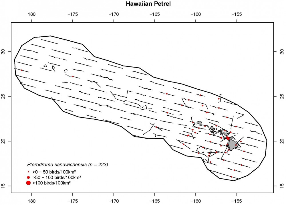
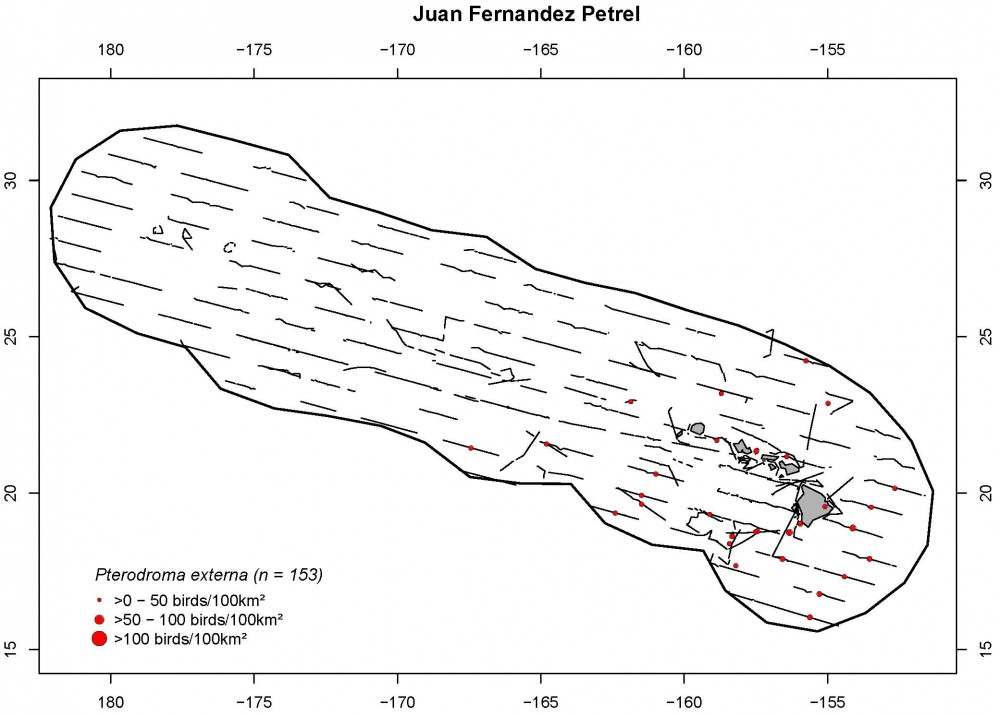
Select Density (birds/100 km2) and Distribution Maps
Sighting Data
Daytime sighting effort within the Hawai‘i EEZ (black outline), including seven ship legs aboard two NOAA ships.
Cetaceans
Summary of cetacean species recorded within the Hawai‘i EEZ, with >10 group encounters during HICEAS. Species seen as part of mixed species groups are counted once for each species.
| Common Name | Total Groups | |
| Short-finned pilot whale | 35 | |
| Striped dolphin | 27 | |
| False killer whale | 27 | |
| Pantropical spotted dolphin | 25 | |
| Rough-toothed dolphin | 25 | |
| Sperm whale | 24 | |
| Unidentified beaked whale | 24 | |
| Unidentified small dolphin | 20 | |
| Unidentified dolphin | 18 | |
| Risso's dolphin | 12 | |
| Cuvier's beaked whale | 11 |
Select Sighting and Distribution Maps
Seabirds
Summary of seabird encounters recorded in the Hawai‘i EEZ with >100 individuals, in descending order of total number of individuals.
| Common Name | Encounters | Individuals |
| Wedge-tailed shearwater (light morph) | 2619 | 5300 |
| Slender-billed (Short-tailed) shearwater | 166 | 2720 |
| Wedge-tailed shearwater (dark morph) | 687 | 2609 |
| Sooty tern | 717 | 2292 |
| Bonin petrel | 1134 | 1673 |
| Black-winged petrel | 799 | 909 |
| Red-footed booby | 521 | 894 |
| Bulwer's petrel | 512 | 578 |
| White tern | 405 | 538 |
| Brown noddy | 130 | 407 |
| Wedge-tailed shearwater | 7 | 345 |
| Great frigatebird | 104 | 319 |
| Black noddy | 94 | 301 |
| Hawaiian petrel | 220 | 248 |
| White-necked petrel | 134 | 211 |
| Brown booby | 142 | 175 |
| Sooty shearwater | 108 | 168 |
| Juan Fernandez petrel | 141 | 162 |
| Shorebird | 105 | 162 |
| Wedge-tailed shearwater (intermediate morph) | 119 | 152 |
| Red-tailed tropicbird | 112 | 124 |
| White-tailed tropicbird | 111 | 121 |
| Black-footed albatross | 99 | 103 |
| Christmas shearwater | 86 | 101 |
Select Density (birds/100 km2) and Distribution Maps
Satellite Tag Location Data
False Killer Whales, n=4
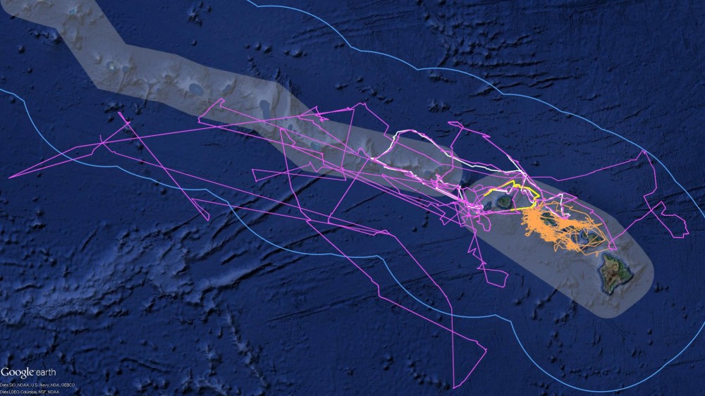
Short-finned Pilot Whales, n=3
Seven satellite tags were deployed on false killer whales and short-finned pilot whales around the Main Hawaiian Islands. These figures show the location of each whale through the duration of each tag deployment.
DASBR Location Data
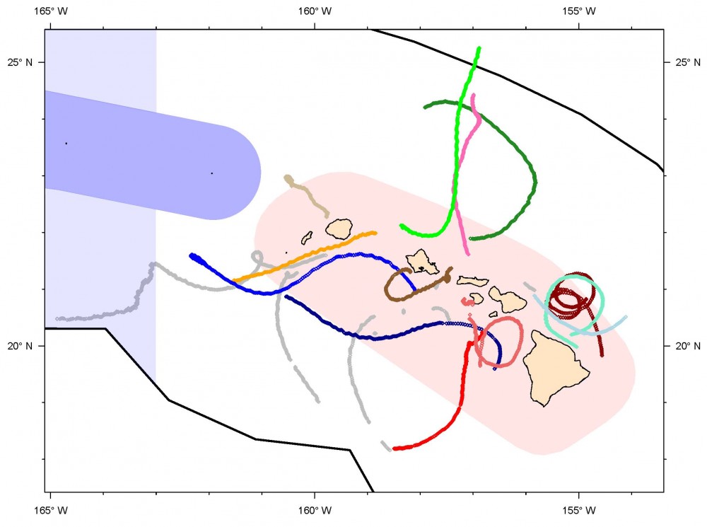
Nineteen Drifting Acoustic Spar Buoy Recorders (DASBRs) were deployed around the Main Hawaiian Islands. Thirteen of the 19 were recovered (location tracks are shown in color) and 6 acoustic recorders were lost at sea (shown in gray).
Satellite Tags and DASBRs
Satellite Tag Location Data
False Killer Whales, n=4
Short-finned Pilot Whales, n=3
Seven satellite tags were deployed on false killer whales and short-finned pilot whales around the Main Hawaiian Islands. These figures show the location of each whale through the duration of each tag deployment.
DASBR Location Data
Nineteen Drifting Acoustic Spar Buoy Recorders (DASBRs) were deployed around the Main Hawaiian Islands. Thirteen of the 19 were recovered (location tracks are shown in color) and 6 acoustic recorders were lost at sea (shown in gray).
- 2 NOAA ships, Sette and Lasker
- 179 days at sea; 161 on-effort survey days
- 46 science staff (cruise leaders, observers, acousticians, and visiting scientists)
- 23,700+ km of transect line traveled
Cetacean Data Collected
- 36,000+ photos taken of 21 species (140 cetacean groups encountered)
- 3.5 TB of photos taken
- 111 biopsy samples of 7 species
- 7 satellite tags deployed
- 888 cumulative hours of daytime acoustic data recorded
- 57.4 TB of acoustic data recorded (monitored, unmonitored, and DASBR recordings)
- 19 Drifting Acoustic Spar Buoy Recorders (DASBRs) were deployed
- 13 DASBRs were recovered and 6 recording units were lost at sea
- 251 days and >6,350 km of drifting DASBR track was recorded
Cetacean Sightings/Detections within the Hawai’i EEZ
- 21 species were seen in 326 sightings
- Short-finned pilot whales were sighted the most frequently, n=36
- 726 acoustic detections of cetaceans (177 were also seen)
Seabird Sightings within the Hawai’i EEZ
- 50 seabird species recorded
- 13 seabird species had a density >100 birds/100 km2
- 557 sightings of seabird feeding flocks
Outside the Hawai’i EEZ
- 19 additional cetacean sightings
- Blue whales and short-beaked common dolphins seen outside of the Hawai’i EEZ
- 40 additional cetacean acoustic detections (11 were also seen)
- 8 additional species of seabirds were recorded
- 2 additional feeding flocks were seen
What’s Next?
- Analyze the acoustic and visual data
- Winter-HICEAS 2019 in January-February to focus on baleen whales
