The Dynamic Waters of Heʻeia Fishpond
C. Aka Beebe(1) (cbeebe@hawaii.edu), Paula Moehlenkamp(1) and Rosanna ʻAnolani Alegado(1,2,3) (1) Dept. Oceanography; (2)Sea Grant College Program; (3)Daniel K. Inouye Center for Microbial Oceanography: Research and Education; University of Hawai'i Mānoa, Honolulu, HI 96822
Loko iʻa (Hawaiian fishponds) represent a unique form of aquaculture innovated by Hawaiians in the 12-13th centuries capable of producing ~1 million kg fish annually. Recent estimates place fishpond production at less than 1% pre-Western levels. Socio-economic forces coupled with land-use change, anthropogenic pollution, and invasive species have dramatically eroded the potential for traditional Hawaiian land and marine food production systems. Plantation style intensive agriculture led to soil erosion, mangroves were introduced to capture land runoff and reduce sediment deposition on coastal reefs.
Heʻeia Fishpond
Heʻeia Fishpond is located on the windward side of Oʻahu situated atop the fringing reef along the interior of Kāneʻohe Bay at the mouth of Heʻeia Stream. The 88 acres of Heʻeia Fishpond was originally fully enclosed by dry-stack rock walls. Over years,the fishpond walls fell into disrepair and became overgrown with Red Mangrove (rhizophora mangle). Paepae o Heʻeia is currently in the process of repairing the walls, physically removing mangrove from thousands of feet of the 7000 foot long wall. The inland perimeter of the fishpond is dominated by Red Mangrove growing in a marshy area on the margin of an extensive wetland nearly 400 acres in area.
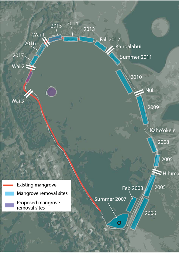
Figure 1: Mangrove removal chronosequence. Circa 2016
Mangroves negatively affect loko iʻa
What are Loko Iʻa?
Loko iʻa (Hawaiian fishponds) represent a unique form of aquaculture innovated by Hawaiians in the 12-13th centuries capable of producing ~1 million kg fish annually. Recent estimates place fishpond production at less than 1% pre-Western levels. Socio-economic forces coupled with land-use change, anthropogenic pollution, and invasive species have dramatically eroded the potential for traditional Hawaiian land and marine food production systems. Plantation style intensive agriculture led to soil erosion, mangroves were introduced to capture land runoff and reduce sediment deposition on coastal reefs.
Heʻeia Fishpond
Heʻeia Fishpond is located on the windward side of Oʻahu situated atop the fringing reef along the interior of Kāneʻohe Bay at the mouth of Heʻeia Stream. The 88 acres of Heʻeia Fishpond was originally fully enclosed by dry-stack rock walls. Over years,the fishpond walls fell into disrepair and became overgrown with Red Mangrove (rhizophora mangle). Paepae o Heʻeia is currently in the process of repairing the walls, physically removing mangrove from thousands of feet of the 7000 foot long wall. The inland perimeter of the fishpond is dominated by Red Mangrove growing in a marshy area on the margin of an extensive wetland nearly 400 acres in area.
Figure 1: Mangrove removal chronosequence. Circa 2016
Mangroves negatively affect loko iʻa
Unfortunately, mangroves dramatically altered shoreline ecosystems: decreasing native flora, contributing to carbon loading, facilitating establishment of non-native benthic fauna and decline of native populations. Recently, local communities are restoring Hawaiian fishponds as a cornerstone of sustainable food production. We partnered with Paepae O Heʻeia, community stewards of the Heʻeia Fishpond on Oʻahu, to investigate the effect of removing a monotypic stand of Rhizophora mangle that hosts a cattle egret rookery.
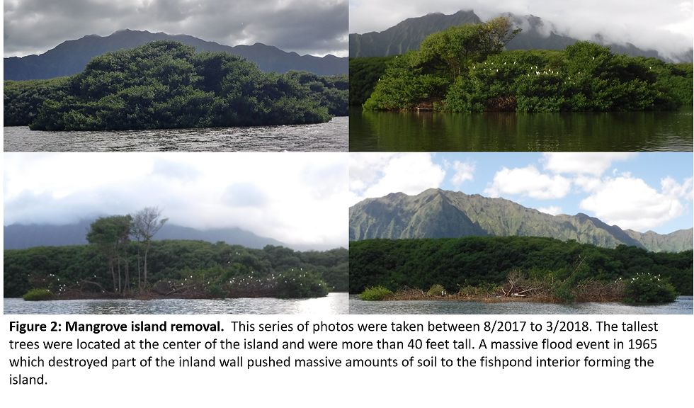
Stopping the Invasion
Unfortunately, mangroves dramatically altered shoreline ecosystems: decreasing native flora, contributing to carbon loading, facilitating establishment of non-native benthic fauna and decline of native populations. Recently, local communities are restoring Hawaiian fishponds as a cornerstone of sustainable food production. We partnered with Paepae O Heʻeia, community stewards of the Heʻeia Fishpond on Oʻahu, to investigate the effect of removing a monotypic stand of Rhizophora mangle that hosts a cattle egret rookery.
Water samples and measurements from 19 sites at Heʻeia fishpond were collected between 2/2017 – 6/2017 for a total of 77 data points. A handheld multiparameter sonde (Yellow Springs Instruments) was used to measure temperature, salinity, dissolved oxygen and pH. Water samples were collected and stored on ice to be filtered and processed. Chemical analysis was done at the SOEST Lab for Analytical Biogeochemistry (S-LAB) for dissolved organic and inorganic nitrogen and phosphorus species as well as silicate. Total suspended solids (TSS) measurements were done gravimetrically.
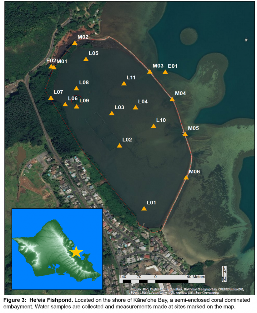
Spatial Heterogeneity in the Fishpond
Data was aggregated for each site by calculating parameter means. The discrete mean values were used to interpolate continuous surfaces over the extant of all sample sites (Figure 4). Distinct gradients can be seen for all parameters measured throughout the fishpond. Heterogeneity driven by physical processes such as circulation and tide is well represented by the gradients in temperature and salinity. Interestingly where there is dense mangrove pH and dissolved oxygen are the lowest supporting the idea of increased input of organic carbon sustaining higher rates of metabolism.
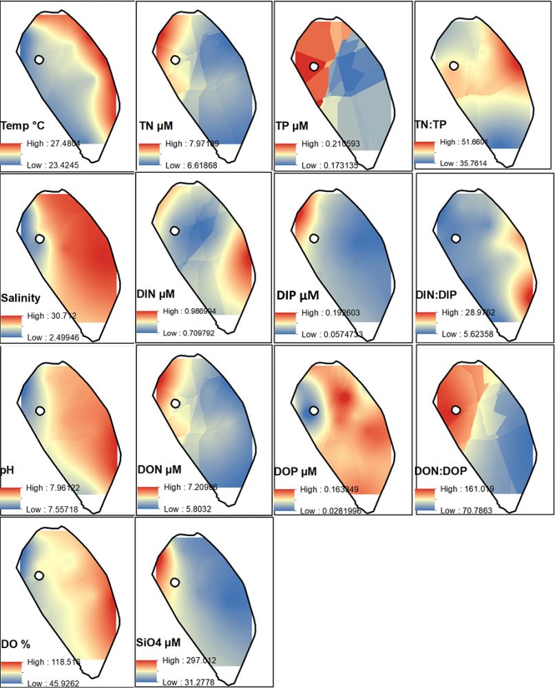
Figure 4: Surface Maps. Various chemical parameters were used in spatial interpolation to assess heterogeneity.
Characterizing the waters of Heʻeia Fishpond
Water samples and measurements from 19 sites at Heʻeia fishpond were collected between 2/2017 – 6/2017 for a total of 77 data points. A handheld multiparameter sonde (Yellow Springs Instruments) was used to measure temperature, salinity, dissolved oxygen and pH. Water samples were collected and stored on ice to be filtered and processed. Chemical analysis was done at the SOEST Lab for Analytical Biogeochemistry (S-LAB) for dissolved organic and inorganic nitrogen and phosphorus species as well as silicate. Total suspended solids (TSS) measurements were done gravimetrically.
Spatial Heterogeneity in the Fishpond
Data was aggregated for each site by calculating parameter means. The discrete mean values were used to interpolate continuous surfaces over the extant of all sample sites (Figure 4). Distinct gradients can be seen for all parameters measured throughout the fishpond. Heterogeneity driven by physical processes such as circulation and tide is well represented by the gradients in temperature and salinity. Interestingly where there is dense mangrove pH and dissolved oxygen are the lowest supporting the idea of increased input of organic carbon sustaining higher rates of metabolism.
Figure 4: Surface Maps. Various chemical parameters were used in spatial interpolation to assess heterogeneity.
We used hierarchical clustering analysis to further investigate the heterogeneity seen in our data (Figure 5). The mean values were first normalized to avoid cluster bias due to differences in the range of parameter values. We found 4 clusters that represent distinct biogeochemical provinces within the fishpond. The importance of this is in the fact that we can now investigate relationships between microbial community composition and the environmental setting.
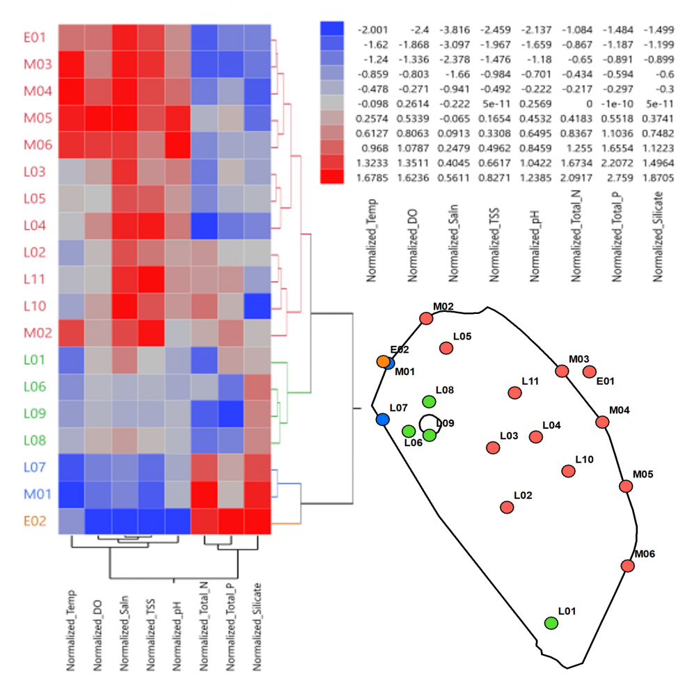
Figure 5: hierarchical clustering. Distinct biogeochemical provinces informed by clustering sites by parameter values.
Distinct Provinces
We used hierarchical clustering analysis to further investigate the heterogeneity seen in our data (Figure 5). The mean values were first normalized to avoid cluster bias due to differences in the range of parameter values. We found 4 clusters that represent distinct biogeochemical provinces within the fishpond. The importance of this is in the fact that we can now investigate relationships between microbial community composition and the environmental setting.
Figure 5: hierarchical clustering. Distinct biogeochemical provinces informed by clustering sites by parameter values.
Acknowledgements
Mahalo to the gang at Paepae o Heʻeia for allowing us to learn about the fishpond through our work. Mahalo to Alegado Lab, Nelson Lab, Lab hui o Frank, for all the work to get this project started. Mahalo to Margaret McManus, Karen Selph and Kathleen Ruttenberg for their help. Mahalo to fellow students who lent a hand at times in the field and at the lab. Mahalo to Kuaʻāina Ulu ʻAuamo. Mahalo to Sea Grant and Department of Health for funding this research. Mahalo to the Hauʻoli Mau Loa Foundation for supporting Mr. Beebeʻs academic work.
