E Kukui, Ke Kukui: Statewide Mapping of Kukui Sheds Light on Traditional Agroforestry across Hawai´i
Kalisi Fa'anunu Mausio, Noa Kekuewa Lincoln, Matthew Lucas, Tanya Torres, Blaire Langston

Aboriculture is one of the diverse types of agricultural systems that pre-contact Hawaiians impletemented. The cultivation of shrubs and trees provided many advantages such as food, medicines, wood, household uses, and protection and nutrients for understory crops. Such agroforests of native and endemic plants were usually found in areas unsuitable for kalo (taro) or 'uala (sweet potato) cultivation, in coastal areas or upland slopes (Lincoln and Vitousek, 2017).
Kukui, Aleurites moluccanus, is a fast growing woody species that was introduced by the Hawaiians for its many uses and was occasionally planted as an overstory crop in the kaluulu cultivation zones and probably in the 'apa'a and 'ama'u zones (Lincoln and Ladefoged, 2014 - see image below) and in marginal agroforests (Lincoln and Vitousek, 2017). It is believed that kukui was an important source of nutrients for kalo cultivation particularly in the windward side of Hawaii Island. Felled kukui that were left to rot, or holes filled with decomposed kukui leaves provided rich organic matter for kalo that grew to great size (Handy 1940).
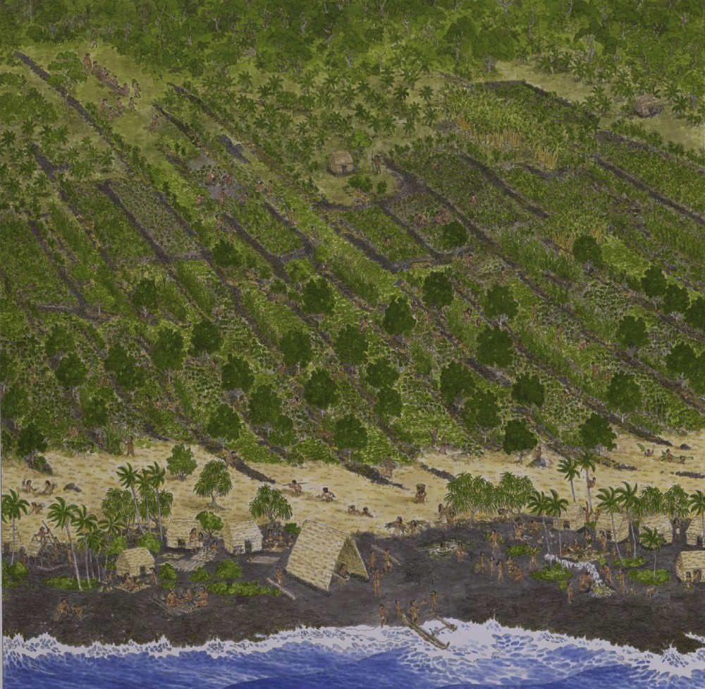
"A modern artist's rendition of the emic agricultural zones of Kona, consisting of the dry lowland plains (kula), the breadfruit plantations (kaluulu), the intensive tuber crop gardens ('apa'a), and the modified upland forests ('ama'u)" (from Lincoln and Ladefoged, 2014).
The Hawai'i Agroforest
Aboriculture is one of the diverse types of agricultural systems that pre-contact Hawaiians impletemented. The cultivation of shrubs and trees provided many advantages such as food, medicines, wood, household uses, and protection and nutrients for understory crops. Such agroforests of native and endemic plants were usually found in areas unsuitable for kalo (taro) or 'uala (sweet potato) cultivation, in coastal areas or upland slopes (Lincoln and Vitousek, 2017).
Kukui, Aleurites moluccanus, is a fast growing woody species that was introduced by the Hawaiians for its many uses and was occasionally planted as an overstory crop in the kaluulu cultivation zones and probably in the 'apa'a and 'ama'u zones (Lincoln and Ladefoged, 2014 - see image below) and in marginal agroforests (Lincoln and Vitousek, 2017). It is believed that kukui was an important source of nutrients for kalo cultivation particularly in the windward side of Hawaii Island. Felled kukui that were left to rot, or holes filled with decomposed kukui leaves provided rich organic matter for kalo that grew to great size (Handy 1940).
"A modern artist's rendition of the emic agricultural zones of Kona, consisting of the dry lowland plains (kula), the breadfruit plantations (kaluulu), the intensive tuber crop gardens ('apa'a), and the modified upland forests ('ama'u)" (from Lincoln and Ladefoged, 2014).
Ka ulu kukui o Lanikaula - The remains of the sacred kukui grove of Lanikaula on Molokai. © Andrew Stehlik
With the advent of settlers and modern agriculture, much of the groves of kukui were replaced with sugarcane and other land uses. Today, obvious signs of pre-contact agriculture such as kalo terraces can be found (many under trees of kukui) in some places, while in others, remnant stands of agroforest trees such as kukui and 'ulu are all that remain as indicators of traditional hawaiian agroforestry.
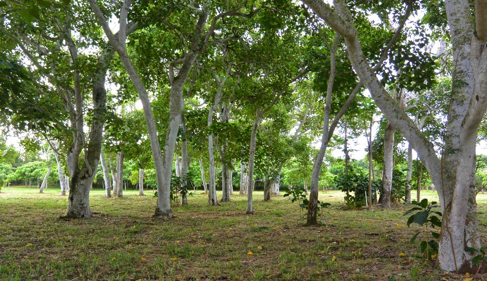
A remnant stand of kukui at Laupahoehoe (between Waipio and Pololu) under which terraces can be found (Hardy 1940). © Hawaii Tourism Authority
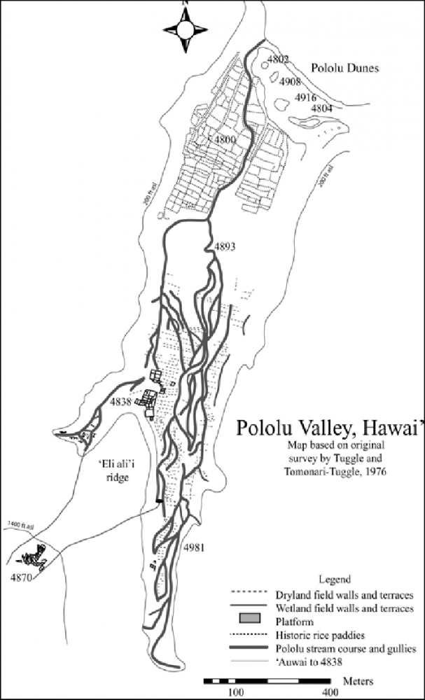
Map of major traditional and historical agricultural complexes identified within Pololū Valley, Kohala (from Graves et al 2014).
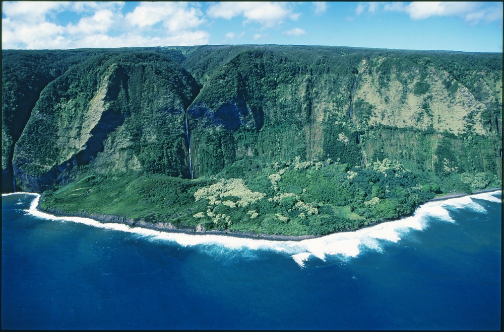
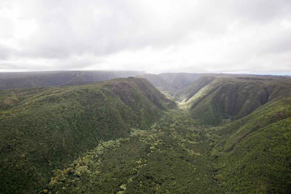
An aerial photo of Pololu today. © Hawaii Toursim Authority
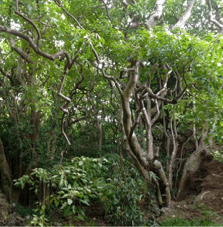
"Representative view of complex of kukui nut trees growing within Kauhaikulepe Gulch", next to Pololu Valley (from Graves et al 2014).
Importance
Ka ulu kukui o Lanikaula - The remains of the sacred kukui grove of Lanikaula on Molokai. © Andrew Stehlik
With the advent of settlers and modern agriculture, much of the groves of kukui were replaced with sugarcane and other land uses. Today, obvious signs of pre-contact agriculture such as kalo terraces can be found (many under trees of kukui) in some places, while in others, remnant stands of agroforest trees such as kukui and 'ulu are all that remain as indicators of traditional hawaiian agroforestry.
A remnant stand of kukui at Laupahoehoe (between Waipio and Pololu) under which terraces can be found (Hardy 1940). © Hawaii Tourism Authority
Map of major traditional and historical agricultural complexes identified within Pololū Valley, Kohala (from Graves et al 2014).
An aerial photo of Pololu today. © Hawaii Toursim Authority
"Representative view of complex of kukui nut trees growing within Kauhaikulepe Gulch", next to Pololu Valley (from Graves et al 2014).
A pilot area in South Kona, Hawaii Island, was chosen to test and perfect the remote sensing algorithm. Preliminary results are show below:
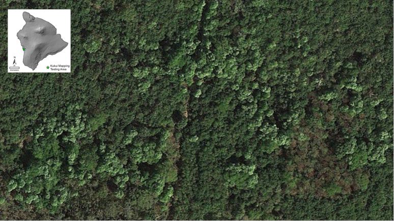
An aerial view of kukui in South Kona.
Mapped kukui in red polygons.
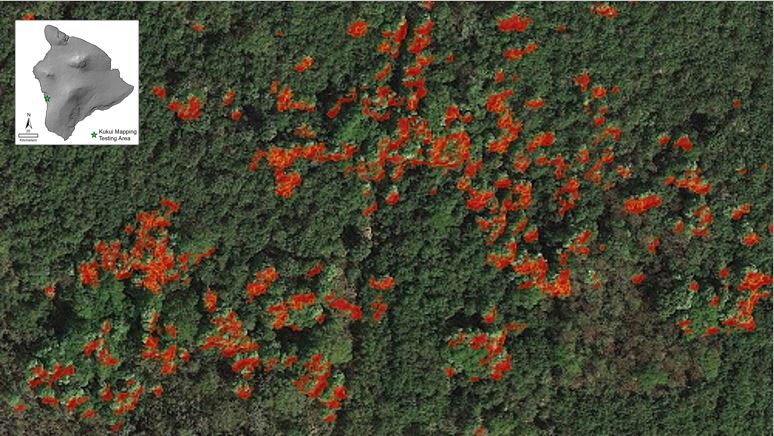
Processing high resolution World View II sattelite imagery (0.4m, 1.5m) over larger areas is a high data intensive endeavor. The 98.5% accuracy acheived in this subset classification is a high level of accuracy that the project aims apply to all imagery statewide.
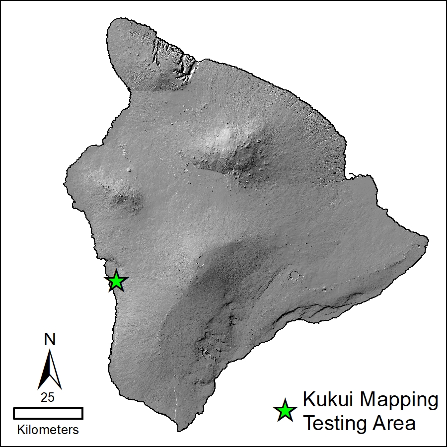
Kukui mapping pilot location
Preliminary Results
A pilot area in South Kona, Hawaii Island, was chosen to test and perfect the remote sensing algorithm. Preliminary results are show below:
An aerial view of kukui in South Kona.
Mapped kukui in red polygons.
Processing high resolution World View II sattelite imagery (0.4m, 1.5m) over larger areas is a high data intensive endeavor. The 98.5% accuracy acheived in this subset classification is a high level of accuracy that the project aims apply to all imagery statewide.
Kukui mapping pilot location
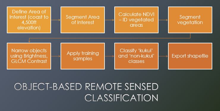
To identify potential remnant agroforestry, we performed high-resolution mapping of kukui statewide using multi-spectral WorldView® II data and object-based remote sensing on Ecognition software. In addtion to acheiving an accuracy of >90%, maps of kukui begin to reveal the tree's current distribution.
An additional step is to perform spatial classification to distinguish between remnant agro-forestry kukui and more contemporary plantings. The spatial attributes of these types of plantings facilitates a classification analysis:
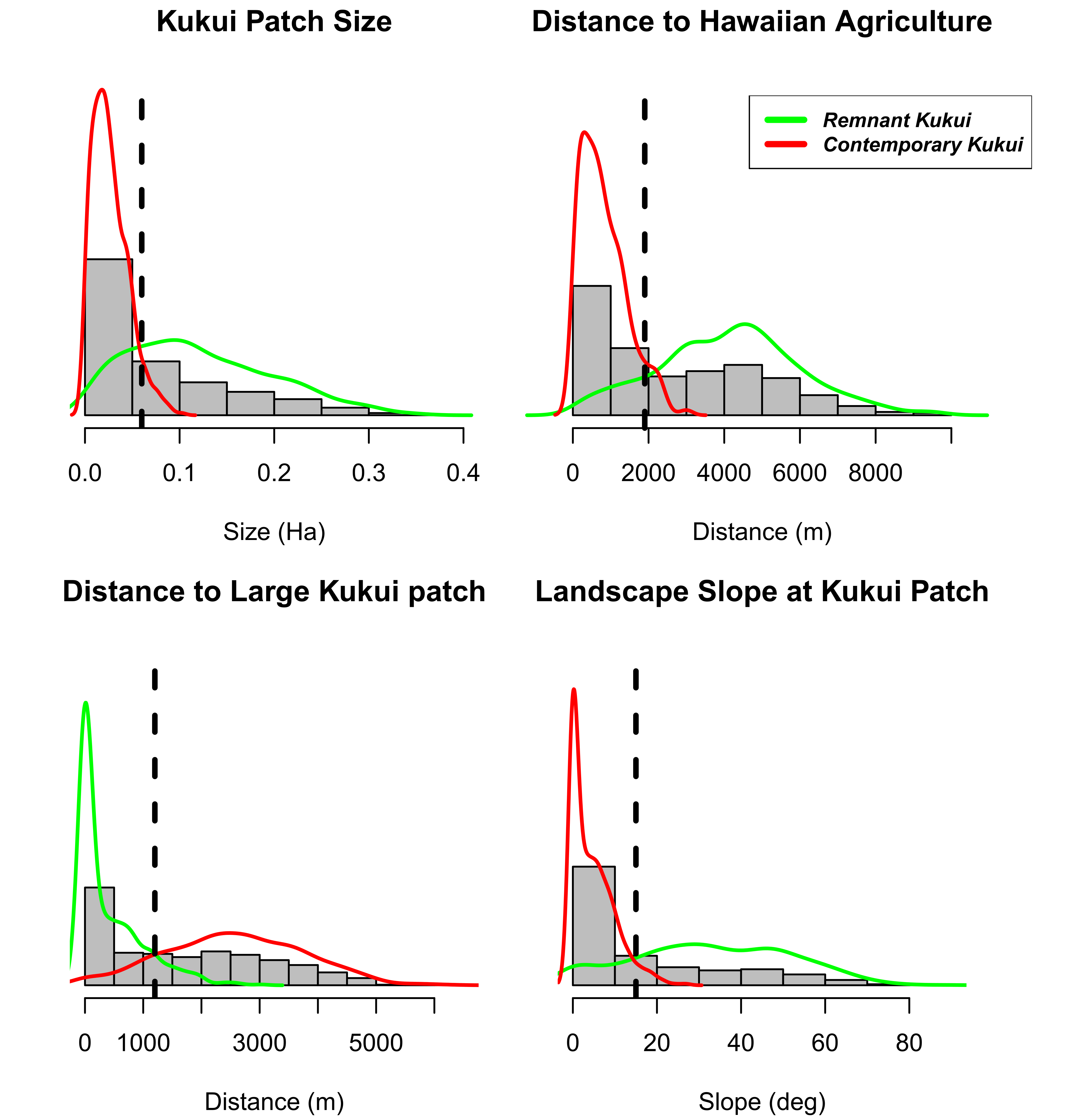
- Remnant Kukui = Larger or adjacent to large patches + farther from modeled Hawaiian agriculture + found on steeper slopes
- Contemporary Kukui = Sparsely distributed from larger previously established kukui + smaller, younger tree crowns.
Examples of conceptual distributions and separation of kukui planting types is shown above. We expect that parsing of these two types of plantings using two or more of this criteria would yield satisfactory results and aid in the understanding of the extent of past Hawaiian agroforestry systems.
Mapping Methodology
To identify potential remnant agroforestry, we performed high-resolution mapping of kukui statewide using multi-spectral WorldView® II data and object-based remote sensing on Ecognition software. In addtion to acheiving an accuracy of >90%, maps of kukui begin to reveal the tree's current distribution.
An additional step is to perform spatial classification to distinguish between remnant agro-forestry kukui and more contemporary plantings. The spatial attributes of these types of plantings facilitates a classification analysis:
- Remnant Kukui = Larger or adjacent to large patches + farther from modeled Hawaiian agriculture + found on steeper slopes
- Contemporary Kukui = Sparsely distributed from larger previously established kukui + smaller, younger tree crowns.
Examples of conceptual distributions and separation of kukui planting types is shown above. We expect that parsing of these two types of plantings using two or more of this criteria would yield satisfactory results and aid in the understanding of the extent of past Hawaiian agroforestry systems.
The Indigenous Cropping Systems laboratory focuses on traditional and low-input farming methods, emphasizing the links between knowledge intensive practices and agricultural production. We employ interdisciplinary methods to generate a holistic understanding of agrarian systems as situated within environmental and social contexts. Our analytical laboratory primarily focuses on biogeochemical analysis, exploring nutrient cycles in plant and soil systems. We also utilize ethnographic and agronomic techniques extensively in field setting across the Pacific. We work closely with farming and indigenous communities, extension faculty and staff, industry players, and high-quality researchers to improve the awareness, understanding, and adoption of traditional practices.
