Kū Hou Kuapā: Increase of water exchange rates and changes in microbial source tracking markers resulting from restoration regimes at Heʻeia Fishpond
Paula Möhlenkamp, Margaret McManus, Craig Nelson, Charles Aka Beebe, Keliʻiahonui Kotubetey, Angela Hiʻilei Kawelo, Brian Glazer, Rosanna ʻAnolani Alegado

Hawaiian fishponds are one of the most ancient and sustainable aquacultures in the world and hold important cultural value.
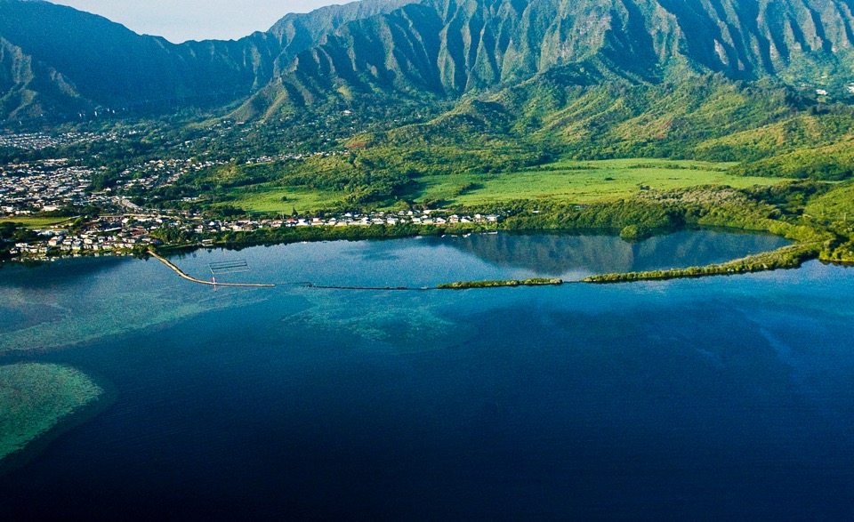
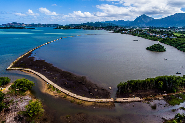
He‘eia fishpond is an example of a traditional Hawaiian aquaculture system located at the terminus of He‘eia ahupua‘a on the windward side of Oʻahu (21°26ʹ10.74ʺ N, 157°48ʹ28.05ʺW). The ahupua‘a system is a uniquely Hawaiian system of environmental resource management, spanning from mauka to makai. The terrestrial and coastal environments were viewed as a coupled system, where everything was interconnected. There were flooded agroecosystems based on taro upstream that captured sediment runoff and enriched the water in nutrients, and fishponds at the terminus of the stream that provided a protein ressource for the community when ocean fishing did not yield sufficient supply. This form of land use was much more resilient to natural desasters and erosion than what we see today and reflects on the deep understanding of the environmental processes specific to our islands, that Hawaiians had and cultured to sustain themselves and future generations.
He‘eia fishponds presents an excellent model system to study coastal ecosystems because it is located at the intersection between land and sea providing the unique opportunity to examine how historical land use change has altered the functions of coastal habitats and how restoration can help to maintain and improve the integrity of ecosystems in the face of rapid global change.
Study Site: He‘eia Fishpond
Hawaiian fishponds are one of the most ancient and sustainable aquacultures in the world and hold important cultural value.
He‘eia fishpond is an example of a traditional Hawaiian aquaculture system located at the terminus of He‘eia ahupua‘a on the windward side of Oʻahu (21°26ʹ10.74ʺ N, 157°48ʹ28.05ʺW). The ahupua‘a system is a uniquely Hawaiian system of environmental resource management, spanning from mauka to makai. The terrestrial and coastal environments were viewed as a coupled system, where everything was interconnected. There were flooded agroecosystems based on taro upstream that captured sediment runoff and enriched the water in nutrients, and fishponds at the terminus of the stream that provided a protein ressource for the community when ocean fishing did not yield sufficient supply. This form of land use was much more resilient to natural desasters and erosion than what we see today and reflects on the deep understanding of the environmental processes specific to our islands, that Hawaiians had and cultured to sustain themselves and future generations.
He‘eia fishponds presents an excellent model system to study coastal ecosystems because it is located at the intersection between land and sea providing the unique opportunity to examine how historical land use change has altered the functions of coastal habitats and how restoration can help to maintain and improve the integrity of ecosystems in the face of rapid global change.
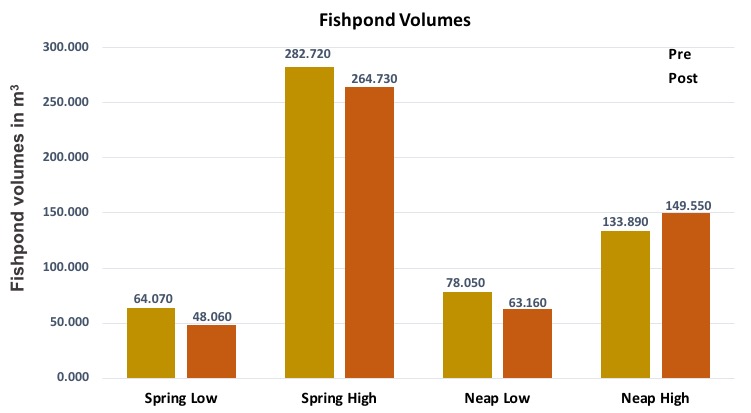
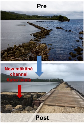
The repair of Ocean Break results in a considerable change of fishpond volume: The construction of an additional mākāhā channel (Kaho‘okele), leads to greater and faster outflux during both spring and neap low tide. Similarly Kaho‘okele allows more influx during neap high tide, resulting in a greater fishpond volume in 2018. Only during spring high tide, water level was previously high enough to pour over the 50 m section of the kuapā called Ocean Break resulting in a lower fishpond volume post restoration.
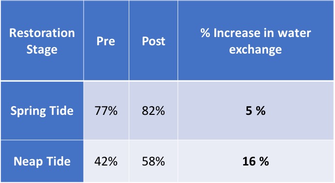
Restoration resulted in a considerable increase of water exchange rates. As a consequence, residence time decreases: The minimum residence time calculated based on spring tide water exchange decreased from 38 hours pre-restoration to 32 hours post restoration. Maximum residence time based on neap tide exchange rates decreased from 102 hours to 64 hours.
It is therefore important to differentiate between tidal states when looking at the effects of Ocean Break repair on the physical environment of the fishpond: Heʻeia fishpond acted largely as an unconfined system during spring tides prior to restoration, when the spring flood tide exceeded the height of Ocean Break. During neap tides however, the fishpond was more confined with less exchange pre-restoration. Hence, the addition of Kahoʻokele increased fishpond water exchange.
Restoration affects fishpond volume and residence time
The repair of Ocean Break results in a considerable change of fishpond volume: The construction of an additional mākāhā channel (Kaho‘okele), leads to greater and faster outflux during both spring and neap low tide. Similarly Kaho‘okele allows more influx during neap high tide, resulting in a greater fishpond volume in 2018. Only during spring high tide, water level was previously high enough to pour over the 50 m section of the kuapā called Ocean Break resulting in a lower fishpond volume post restoration.
Restoration resulted in a considerable increase of water exchange rates. As a consequence, residence time decreases: The minimum residence time calculated based on spring tide water exchange decreased from 38 hours pre-restoration to 32 hours post restoration. Maximum residence time based on neap tide exchange rates decreased from 102 hours to 64 hours.
It is therefore important to differentiate between tidal states when looking at the effects of Ocean Break repair on the physical environment of the fishpond: Heʻeia fishpond acted largely as an unconfined system during spring tides prior to restoration, when the spring flood tide exceeded the height of Ocean Break. During neap tides however, the fishpond was more confined with less exchange pre-restoration. Hence, the addition of Kahoʻokele increased fishpond water exchange.
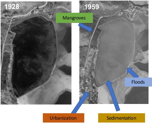
He‘eia fishpond has been altered profoundly through anthropogenic impacts. Over the last century most native Hawaiian fishponds demised due to a combination of social, economic and natural influences:
-
Plantation-style agriculture replaced traditional system (post 1800s)
-
Soil erosion and sedimentation
-
Overgrowth by invasive species
-
Urbanization
-
Nutrification and Anoxia
-
Storm surge impacts
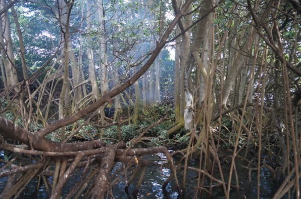
In Hawai‘i mangroves are invasive and have a variety of negative ecological impacts including the transformation of nearshore sandy habitat into heavily vegetated areas with low water velocity, high sedimentation rates, and anoxic sediments through bacterial decomposition of mangrove leaf detritus. For a confined, shallow water environment as He‘eia fishpond that has important implications as consistent aeration and circulation is crucial to maintain stable oxygen levels for fish survival. For that reason the removal of mangroves presents an important management practice.

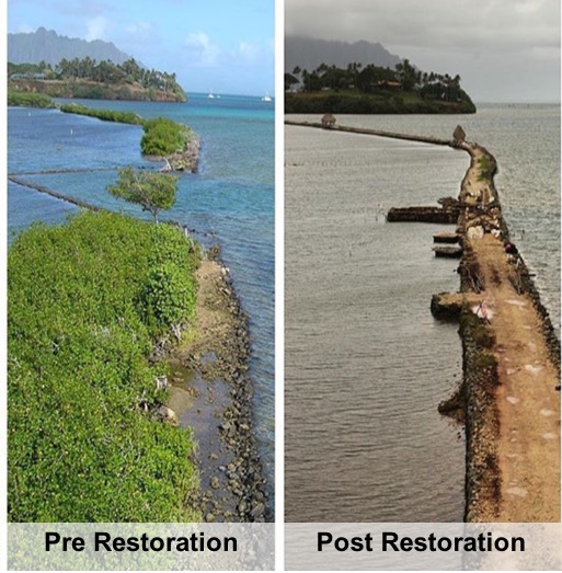
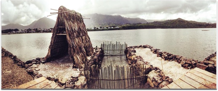
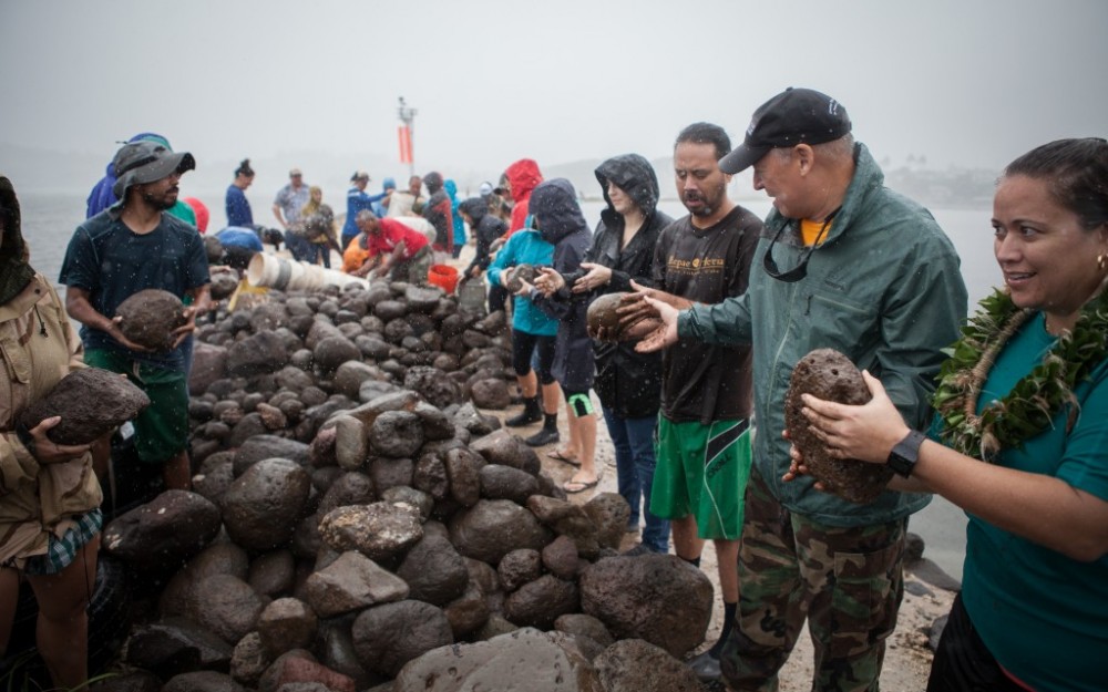
Another important restoration step is the rehabilitation of “Ocean Break”, a section in the kuapā that was broken open during a major flood event in 1965.
Restoration regimes at the fishpond are managed by the nonprofit organization Paepae o He‘eia, that seeks to restore Heʻeia for the community by linking indigenous knowledge to modern management pactices.
Restoration regimes: Mangrove removal & kuapā rehabilitation
He‘eia fishpond has been altered profoundly through anthropogenic impacts. Over the last century most native Hawaiian fishponds demised due to a combination of social, economic and natural influences:
-
Plantation-style agriculture replaced traditional system (post 1800s)
-
Soil erosion and sedimentation
-
Overgrowth by invasive species
-
Urbanization
-
Nutrification and Anoxia
-
Storm surge impacts
In Hawai‘i mangroves are invasive and have a variety of negative ecological impacts including the transformation of nearshore sandy habitat into heavily vegetated areas with low water velocity, high sedimentation rates, and anoxic sediments through bacterial decomposition of mangrove leaf detritus. For a confined, shallow water environment as He‘eia fishpond that has important implications as consistent aeration and circulation is crucial to maintain stable oxygen levels for fish survival. For that reason the removal of mangroves presents an important management practice.
Another important restoration step is the rehabilitation of “Ocean Break”, a section in the kuapā that was broken open during a major flood event in 1965.
Restoration regimes at the fishpond are managed by the nonprofit organization Paepae o He‘eia, that seeks to restore Heʻeia for the community by linking indigenous knowledge to modern management pactices.
The focus of this study was to understand how different parts of the ecosystem change as a consequence of restoration. We hypothesize that the closure of Ocean Break with the integration of an additional mākāhā channel, and the large-scale removal of mangroves along the northern pond periphery has altered water circulation, salinity and microbial source tracking markers in the fishpond. This study addresses the following questions:
-
What were the consequences of restoration on dominant flow pathways for water exchange, fishpond volume and residence time?
-
How do fishpond circulation dynamics reflect in salinity distribution and stratification?
-
How do changes in salinity and circulation affect microbial abundance?
Areas of sediment accumulation show, where mangroves have recently been cleared. The first fresh water mākāhā was cleared in 2015 increasing the amount of river flushing into the fishpond.
Goals and Objective
The focus of this study was to understand how different parts of the ecosystem change as a consequence of restoration. We hypothesize that the closure of Ocean Break with the integration of an additional mākāhā channel, and the large-scale removal of mangroves along the northern pond periphery has altered water circulation, salinity and microbial source tracking markers in the fishpond. This study addresses the following questions:
-
What were the consequences of restoration on dominant flow pathways for water exchange, fishpond volume and residence time?
-
How do fishpond circulation dynamics reflect in salinity distribution and stratification?
-
How do changes in salinity and circulation affect microbial abundance?
Areas of sediment accumulation show, where mangroves have recently been cleared. The first fresh water mākāhā was cleared in 2015 increasing the amount of river flushing into the fishpond.
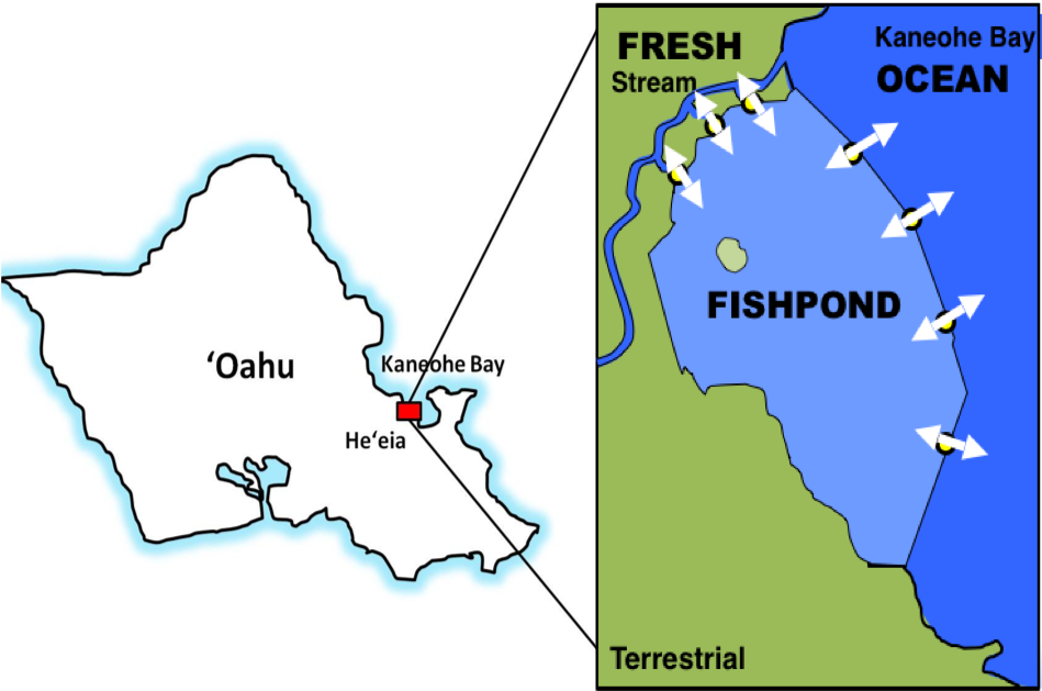
Because of distinctive salinities from two sources of water to He‘eia Fishpond (Kāne’ohe Bay and He‘eia Stream), salinity can be used to track the relative proportion of stream versus ocean water within the fishpond.
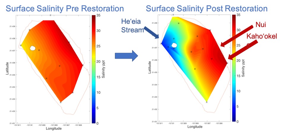
Salinity in surface waters displayed a spatial gradient across the fishpond. Higher salinities are observed on the Kāne’ohe Bay side of the fishpond with a steep salinity gradient localized near the river mākāhā. Comparison with pre restoration data reveals a freshening of the fishpond with overall significantly lower salinities. As weather conditions were comparable the observed change can be attributed to the removal of mangroves around freshwater mākāhā Wai 1.
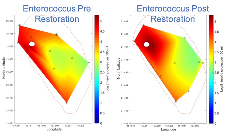
Abundance of microbial source tracking markers reveal a strong inverse correlation with salinity reflected in their spatial distribution. Despite increased flushing rates, abundance of Enterococcus and Bacteroidales, did not show a significant change in average abundance when comparing pre and post restoration. Enterococcus and Bacteroidales are two microbes associated with fecal contamination from mammals that have been used by the EPA for regulatory action. As these microbes are likely introduced to the fishpond via terrigenous input, the freshening of the fishpond environment presents a mechanism increasing microbial abundance, hence counteracting the positive effect of increased flushing rates.
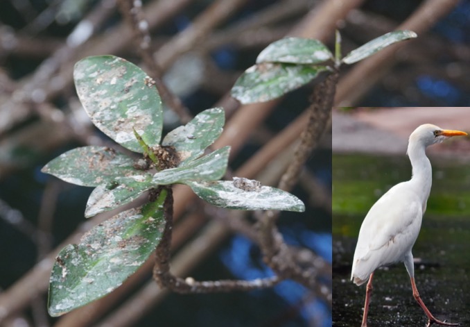
The fishpond is home to a large cattle egret colony, a potential source of microbial contamination.
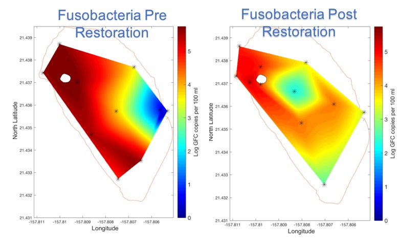
Fusobacterium, a fecal indicator bacterium specific to birds that has been used to detect fecal contamination from avian species in coastal environments, revealed a significant decrease in average abundance post restoration. As the source of contamination is the cattle egret colony within the fishpond, the change can be attributed to increased flushing rates and lower residence times.
Restoration affects salinity and microbial source tracking markers
Because of distinctive salinities from two sources of water to He‘eia Fishpond (Kāne’ohe Bay and He‘eia Stream), salinity can be used to track the relative proportion of stream versus ocean water within the fishpond.
Salinity in surface waters displayed a spatial gradient across the fishpond. Higher salinities are observed on the Kāne’ohe Bay side of the fishpond with a steep salinity gradient localized near the river mākāhā. Comparison with pre restoration data reveals a freshening of the fishpond with overall significantly lower salinities. As weather conditions were comparable the observed change can be attributed to the removal of mangroves around freshwater mākāhā Wai 1.
Abundance of microbial source tracking markers reveal a strong inverse correlation with salinity reflected in their spatial distribution. Despite increased flushing rates, abundance of Enterococcus and Bacteroidales, did not show a significant change in average abundance when comparing pre and post restoration. Enterococcus and Bacteroidales are two microbes associated with fecal contamination from mammals that have been used by the EPA for regulatory action. As these microbes are likely introduced to the fishpond via terrigenous input, the freshening of the fishpond environment presents a mechanism increasing microbial abundance, hence counteracting the positive effect of increased flushing rates.
The fishpond is home to a large cattle egret colony, a potential source of microbial contamination.
Fusobacterium, a fecal indicator bacterium specific to birds that has been used to detect fecal contamination from avian species in coastal environments, revealed a significant decrease in average abundance post restoration. As the source of contamination is the cattle egret colony within the fishpond, the change can be attributed to increased flushing rates and lower residence times.
The flux of water into the fishpond through mākāhā was quantified by current meters deployed over several tidal cycles in each of the 6 mākāhā channels. Water volume flux (φ, m3 s-1) was determined for all mākāhā using the equation:
φ= wdv
where w is the mākāhā width (m), d is the water depth (m) at a particular tidal stage, and v is the water velocity (m s-1).
Rating curves reveal that water exchange at mākāhā is largely tidally driven during non-storm/baseline conditions.
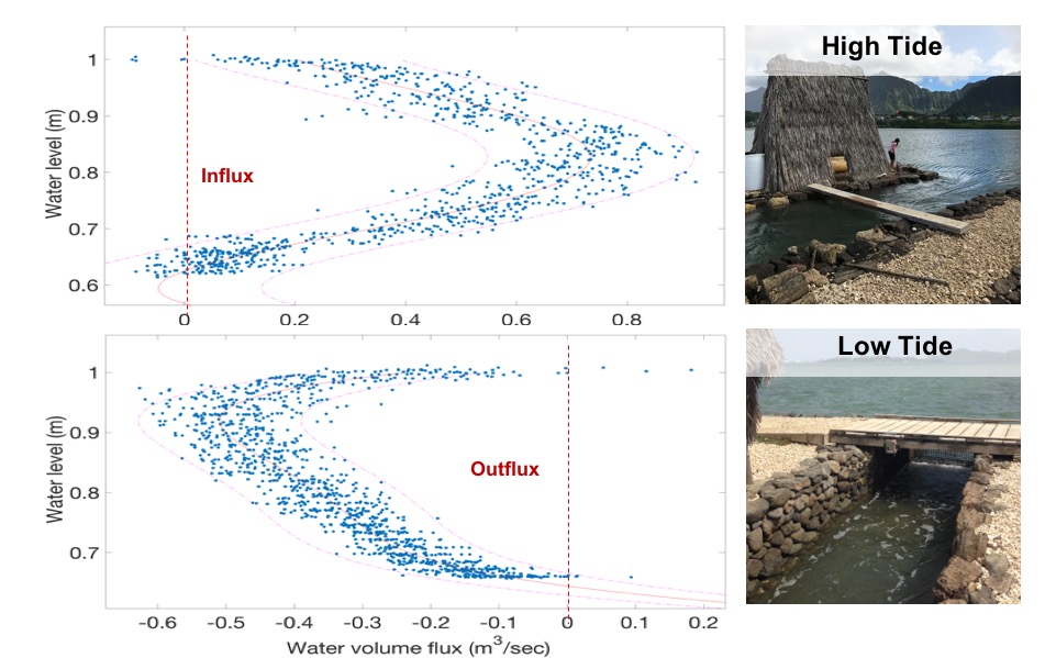
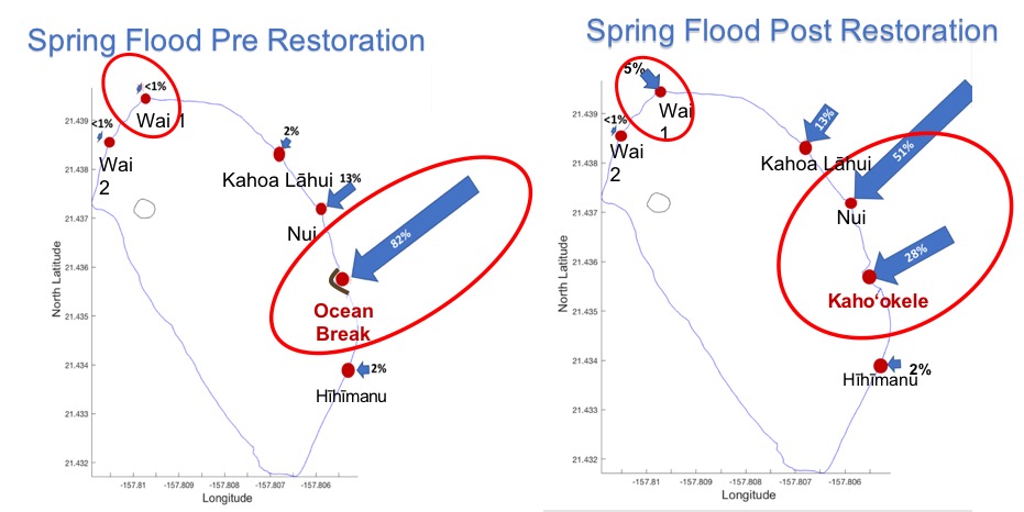
Relative flux distribution reveals that three mākāhā bordering Kāneʻohe Bay in the northeast account together for 90% of exchange. Restoration causes a redistribution of water exchange due to the closure of Ocean Break and the integration of a new mākāha channel. Fresh water flushing at Wai 1 increases due to mangrove removal.
Mākāhā water exchange is tidally driven
The flux of water into the fishpond through mākāhā was quantified by current meters deployed over several tidal cycles in each of the 6 mākāhā channels. Water volume flux (φ, m3 s-1) was determined for all mākāhā using the equation:
φ= wdv
where w is the mākāhā width (m), d is the water depth (m) at a particular tidal stage, and v is the water velocity (m s-1).
Rating curves reveal that water exchange at mākāhā is largely tidally driven during non-storm/baseline conditions.
Relative flux distribution reveals that three mākāhā bordering Kāneʻohe Bay in the northeast account together for 90% of exchange. Restoration causes a redistribution of water exchange due to the closure of Ocean Break and the integration of a new mākāha channel. Fresh water flushing at Wai 1 increases due to mangrove removal.
- Circulation within He‘eia Fishpond is driven by physical processes: tidal forcing, wind forcing and stream input.
- The addition of a new mākāhā channel (kaho’kele) results in a considerable increase of water exchange and therefore in a decrease of water residence time pre to post restoration.
- Placing an additional mākāhā in the seawall improved circulation in the eastern portion of the fishpond during all tidal states. Kaho‘okele accounts now for a significant share of water volume flux.
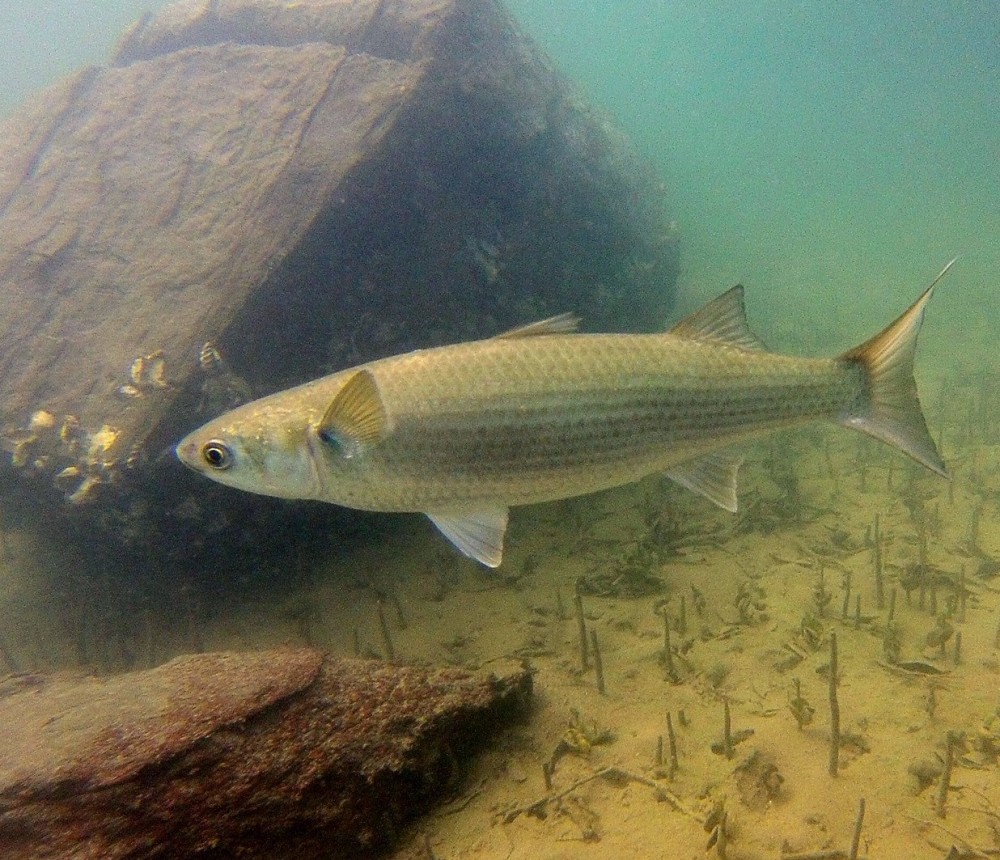
- Increased flushing reduces the risk of fish mortality as a result of hypoxic stress during warming events.
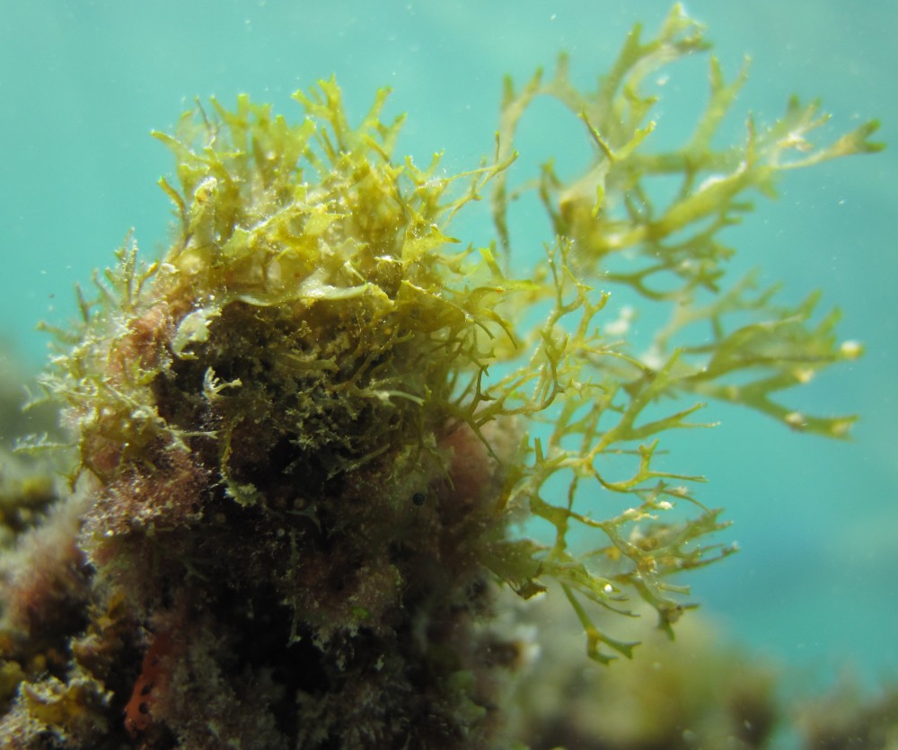
- Mangrove removal resulted in a freshening of the fishpond environment, beneficial for native limu the primary food source for target fish species.
- In order to improve water quality, we need to reduce pollution upstream and work as a community to restore this culturally and economically important site for sustainable aquaculture in the future.
- Understanding the physical environment of He’eia Fishpond will advance our knowledge of the dynamic biochemical and physical interactions in Hawaiian estuarine ecosystems.
Future implications
- Circulation within He‘eia Fishpond is driven by physical processes: tidal forcing, wind forcing and stream input.
- The addition of a new mākāhā channel (kaho’kele) results in a considerable increase of water exchange and therefore in a decrease of water residence time pre to post restoration.
- Placing an additional mākāhā in the seawall improved circulation in the eastern portion of the fishpond during all tidal states. Kaho‘okele accounts now for a significant share of water volume flux.
- Increased flushing reduces the risk of fish mortality as a result of hypoxic stress during warming events.
- Mangrove removal resulted in a freshening of the fishpond environment, beneficial for native limu the primary food source for target fish species.
- In order to improve water quality, we need to reduce pollution upstream and work as a community to restore this culturally and economically important site for sustainable aquaculture in the future.
- Understanding the physical environment of He’eia Fishpond will advance our knowledge of the dynamic biochemical and physical interactions in Hawaiian estuarine ecosystems.
