Ultra High Resolution Mapping of Coral Reefs Utilizing Modern Unmanned Aerial System (UAS) Technology
Robert O’Conner - robert.oconner@noaa.gov

With the State of Hawaiʻi 's coral reef resources under increasing stress from changes in ocean chemistry, sea level rise, and direct anthropogenic factors, it is more urgent than ever to use applicable emerging technologies to study and monitor these delicate natural resources. Unmanned Aerial Systems (UAS) provide an efficient and relatively low cost method for obtaining ultra high resolution imagery of native coral reef species in the Hawaiian Islands. The availability of hybrid vertical take off and landing (VTOL) aircraft enable the researcher to launch and recover fixed wing aircraft from small landing areas such as a research boat greatly increasing the amount of coral reef ecosystems that can be mapped in a single flight. Incorporating both high resolution optical cameras as well as multispectral sensors can provide insight into coral reef health previously unable to obtain at low altitudes and ultra high resolutions. This study aims to incorporate state of the art VTOL UAS to continually monitor those study sites of importance to the National Oceanic & Atmospheric Administration (NOAA) and the State of Hawaiʻi in Kaneohe Bay. The data collected will ultimately provide a foundation for future conservation efforts in the near shore marine environment.
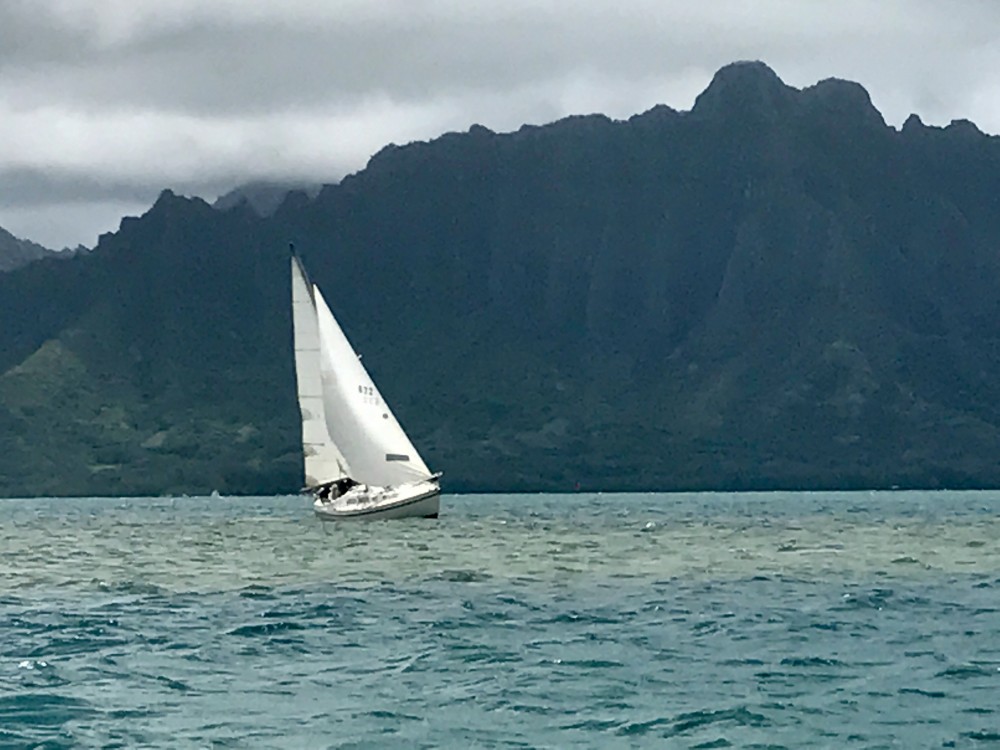
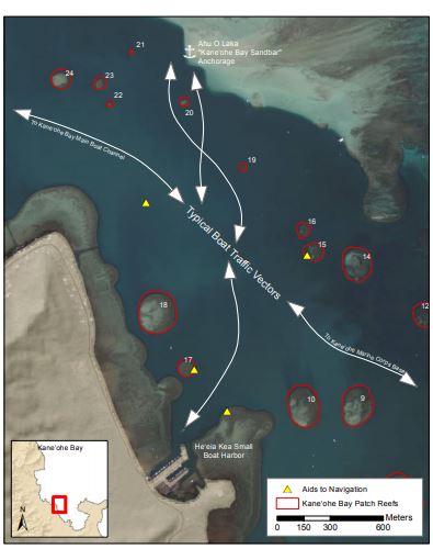
Threat to Coral Reefs in Hawai’i: Vessel Groundings
There is a relatively high volume of observed boat traffic in Hawai’i. Historically, the use of thrill craft, recreational boating, and tour group activities have produced congestion on Hawaiʻi’s waterways (Lowe 1995). Hawai’i is also home to a high concentration of marinas, harbors, and piers including major international ports of entry. Kane’ohe Bay in particular has a high concentration of recreational marinas making it a viable pilot project site (Figure 1). Inevitably, a proportion of boats will run aground on the patch and fringing reefs that are spread throughout the bay whether due to human error, environmental conditions such as tides, winds, mechanical error, or a combination of these factors (Chauvin 1972). Boat groundings lead to broken and crushed corals as well as the creation of bare substrate for colonization by invasive species and elimination of topographic/habitat complexity (Precht 2001).
Introduction
With the State of Hawaiʻi 's coral reef resources under increasing stress from changes in ocean chemistry, sea level rise, and direct anthropogenic factors, it is more urgent than ever to use applicable emerging technologies to study and monitor these delicate natural resources. Unmanned Aerial Systems (UAS) provide an efficient and relatively low cost method for obtaining ultra high resolution imagery of native coral reef species in the Hawaiian Islands. The availability of hybrid vertical take off and landing (VTOL) aircraft enable the researcher to launch and recover fixed wing aircraft from small landing areas such as a research boat greatly increasing the amount of coral reef ecosystems that can be mapped in a single flight. Incorporating both high resolution optical cameras as well as multispectral sensors can provide insight into coral reef health previously unable to obtain at low altitudes and ultra high resolutions. This study aims to incorporate state of the art VTOL UAS to continually monitor those study sites of importance to the National Oceanic & Atmospheric Administration (NOAA) and the State of Hawaiʻi in Kaneohe Bay. The data collected will ultimately provide a foundation for future conservation efforts in the near shore marine environment.
Threat to Coral Reefs in Hawai’i: Vessel Groundings
There is a relatively high volume of observed boat traffic in Hawai’i. Historically, the use of thrill craft, recreational boating, and tour group activities have produced congestion on Hawaiʻi’s waterways (Lowe 1995). Hawai’i is also home to a high concentration of marinas, harbors, and piers including major international ports of entry. Kane’ohe Bay in particular has a high concentration of recreational marinas making it a viable pilot project site (Figure 1). Inevitably, a proportion of boats will run aground on the patch and fringing reefs that are spread throughout the bay whether due to human error, environmental conditions such as tides, winds, mechanical error, or a combination of these factors (Chauvin 1972). Boat groundings lead to broken and crushed corals as well as the creation of bare substrate for colonization by invasive species and elimination of topographic/habitat complexity (Precht 2001).
![]()
Step 1: Federal guidelines require appropriate permits be in place including authorization from NOAA’s Aircraft Operations Center (AOV) and the FAA. In addition, a waiver was obtained in order to fly within the five mile vicinity of the Kāneʻohe Marine Corps Base.
Step 2: Data collection takes place either from land or a small boat thanks to the VTOL capabilities of the FireFLY6 PRO.
Step 3: Optical imagery and multispectral imagery is collected autonomously thanks to the included flight control software, AvA.
The Sony A6000 and Parrot Sequoia multispectral sensor can be swapped out in seconds.
Step 4: Images are mosaicked using ESRI’s Drone2Map software which digests images and automatically produces georeferenced imagery and associated point clouds for 3D interpretation.
Step 5: Once in the GIS, the imagery can be analyzed quantify vessel damage, benthic habitat characteristics, and flora/fauna assemblages.
Step 6: Field validated injury areas will be photographed in situ and linked to coordinates in the GIS.
Methodology of UAS Data Aquisition
![]()
Step 1: Federal guidelines require appropriate permits be in place including authorization from NOAA’s Aircraft Operations Center (AOV) and the FAA. In addition, a waiver was obtained in order to fly within the five mile vicinity of the Kāneʻohe Marine Corps Base.
Step 2: Data collection takes place either from land or a small boat thanks to the VTOL capabilities of the FireFLY6 PRO.
Step 3: Optical imagery and multispectral imagery is collected autonomously thanks to the included flight control software, AvA.
The Sony A6000 and Parrot Sequoia multispectral sensor can be swapped out in seconds.
Step 4: Images are mosaicked using ESRI’s Drone2Map software which digests images and automatically produces georeferenced imagery and associated point clouds for 3D interpretation.
Step 5: Once in the GIS, the imagery can be analyzed quantify vessel damage, benthic habitat characteristics, and flora/fauna assemblages.
Step 6: Field validated injury areas will be photographed in situ and linked to coordinates in the GIS.
Benthic habitat maps allow for a better understanding of the seascape, ecosystem function and species habitat utilization patterns in coastal areas and are most useful when they are created at a scale that is relevant to management actions (Wedding 2006). Fisheries scientists have identified mapping of coral reefs and fish habitats as being highly important for maintaining sustainable fisheries (SFA 1996).
Unfortunately, techniques used in a terrestrial setting are not always easily transferred to an underwater setting. Diver limitations of depth and time underwater as well as oceanographic conditions provide unique challenges. Other UAS mapping involves either short endurance aircraft or expensive unmanned aircraft (> $10K) not available to all government or university researchers.
Existing Marine Data for Hawai’i
Existing GIS data include satellite imagery, LIDAR, diver survey data, and boat based sonar data. Unfortunately, the cost and/or resolution of these data are not conducive to mapping vessel damage.
The FireFLY6 PRO UAS can obtain sub-centimeter resolution data beyond the optical spectrum.
Hawai’i Research Techniques
Benthic habitat maps allow for a better understanding of the seascape, ecosystem function and species habitat utilization patterns in coastal areas and are most useful when they are created at a scale that is relevant to management actions (Wedding 2006). Fisheries scientists have identified mapping of coral reefs and fish habitats as being highly important for maintaining sustainable fisheries (SFA 1996).
Unfortunately, techniques used in a terrestrial setting are not always easily transferred to an underwater setting. Diver limitations of depth and time underwater as well as oceanographic conditions provide unique challenges. Other UAS mapping involves either short endurance aircraft or expensive unmanned aircraft (> $10K) not available to all government or university researchers.
Existing Marine Data for Hawai’i
Existing GIS data include satellite imagery, LIDAR, diver survey data, and boat based sonar data. Unfortunately, the cost and/or resolution of these data are not conducive to mapping vessel damage.
The FireFLY6 PRO UAS can obtain sub-centimeter resolution data beyond the optical spectrum.
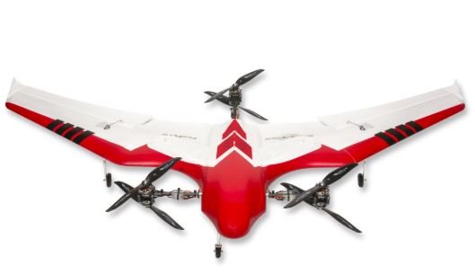
UAS can be an inexpensive alternative to traditional coral reef mapping techniques. In this case, a FireFLY6 PRO is being implemented. The FireFLY6 PRO is a vertical take-off and landing (VTOL) UAS which provides the take-off and landing capabilities of a quadcopter with the ability to transition to fixed wing flight. Fixed wing flight provides increased endurance (up to one hour).
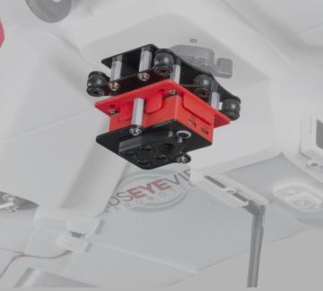
The optical camera: Sony A6000
The interchangeable 24 megapixel Sony a6000 is ideal for general mapping and surveying applications. Pair this payload with the post-processing software of your choice to transform captured images into a georeferenced map or 3D model.
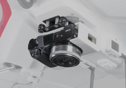
The multispectral sensor: Parrot Sequoia
The Sequoia multispectral sensor captures both visible and invisible images, providing calibrated data to optimally monitor crop health and vigor. The Sequoia captures calibrated wavelength, green, red, red-edge and near infrared to highlight the health of plants.
Benefits over other VTOL UAS: Less expensive & ability to swap payloads.
The Solution: VTOL UAS
UAS can be an inexpensive alternative to traditional coral reef mapping techniques. In this case, a FireFLY6 PRO is being implemented. The FireFLY6 PRO is a vertical take-off and landing (VTOL) UAS which provides the take-off and landing capabilities of a quadcopter with the ability to transition to fixed wing flight. Fixed wing flight provides increased endurance (up to one hour).
The optical camera: Sony A6000
The interchangeable 24 megapixel Sony a6000 is ideal for general mapping and surveying applications. Pair this payload with the post-processing software of your choice to transform captured images into a georeferenced map or 3D model.
The multispectral sensor: Parrot Sequoia
The Sequoia multispectral sensor captures both visible and invisible images, providing calibrated data to optimally monitor crop health and vigor. The Sequoia captures calibrated wavelength, green, red, red-edge and near infrared to highlight the health of plants.
Benefits over other VTOL UAS: Less expensive & ability to swap payloads.
Practice flights are conducted over land in Kailua before flying over the ocean.
References
Jameson SC, Erdmann MV, Karr JR, Gibson GR Jr, Potts KW, 2007. Development of Biological Criteria for Coral Reef Ecosystem Assessment, U.S. EPA report.
Chauvin, L. E. 1972. U.S. Patent No. 3,693,569. Washington, DC: U.S. Patent and Trademark Office.
Lowe, M. K. (1995, June). The Main Hawaiian Islands Marine Resources Investigation (MHI-MRI): Integrated watershed and inshore fisheries management to conserve Hawaiian coastal fisheries ecosystems. In Manuscript Collection of Country Statements and Background Papers. South Pacific Commission and Forum Fisheries Agency Workshop on the Management of South Pacific Inshore Fisheries. Noumea, New Caledonia. BP (Vol. 76, No. 2, pp. 677-691).
Precht, William F.; Aronson, Richard B.; Swanson, Dione W., 2001. Improving scientific decision-making in the restoration of ship-grounding sites on coral reefs, Bulletin of Marine Science, Volume 69, Number 2, September 2001, pp. 1001-1012(12).
Wedding, L., 2006. Coral Reef Mapping For Ecosystem-Based Fisheries Management, Masters Thesis, University of Hawaii, UMI Dissertation Publishing.
Implementing the UAS
Practice flights are conducted over land in Kailua before flying over the ocean.
References
Jameson SC, Erdmann MV, Karr JR, Gibson GR Jr, Potts KW, 2007. Development of Biological Criteria for Coral Reef Ecosystem Assessment, U.S. EPA report.
Chauvin, L. E. 1972. U.S. Patent No. 3,693,569. Washington, DC: U.S. Patent and Trademark Office.
Lowe, M. K. (1995, June). The Main Hawaiian Islands Marine Resources Investigation (MHI-MRI): Integrated watershed and inshore fisheries management to conserve Hawaiian coastal fisheries ecosystems. In Manuscript Collection of Country Statements and Background Papers. South Pacific Commission and Forum Fisheries Agency Workshop on the Management of South Pacific Inshore Fisheries. Noumea, New Caledonia. BP (Vol. 76, No. 2, pp. 677-691).
Precht, William F.; Aronson, Richard B.; Swanson, Dione W., 2001. Improving scientific decision-making in the restoration of ship-grounding sites on coral reefs, Bulletin of Marine Science, Volume 69, Number 2, September 2001, pp. 1001-1012(12).
Wedding, L., 2006. Coral Reef Mapping For Ecosystem-Based Fisheries Management, Masters Thesis, University of Hawaii, UMI Dissertation Publishing.
