Stewardship Mapping and Assessment Project in North Kona and South Kohala
Initial Results from Hawai‘i Island and Expansion to O‘ahu
The Stewardship Mapping and Assessment Project (STEW-MAP) aims to better understand stewardship, identify gaps and overlaps, and create resources to strengthen capacity to mālama ‘āina or steward the environment. STEW-MAP addresses the questions:
Who are the active groups in my area?
Where, why, and how are they caring for the land?
STEW-MAP collects survey data to create a public, online stewardship database and map of community, civic, and other organizations that mālama ‘āina and kai—including those that conserve, restore, manage, monitor, transform, advocate for, engage with, and/or education about the local environment.
INTRODUCTION
The Stewardship Mapping and Assessment Project (STEW-MAP) aims to better understand stewardship, identify gaps and overlaps, and create resources to strengthen capacity to mālama ‘āina or steward the environment. STEW-MAP addresses the questions:
Who are the active groups in my area?
Where, why, and how are they caring for the land?
STEW-MAP collects survey data to create a public, online stewardship database and map of community, civic, and other organizations that mālama ‘āina and kai—including those that conserve, restore, manage, monitor, transform, advocate for, engage with, and/or education about the local environment.
Group Characteristics
Most community/civic groups who participated in the survey:
- Have / have applied for 501c(3) status
- Have 5 or fewer full-time staff, 5 or fewer part-time staff, and 10 or fewer regular volunteers
- Annual budgets of >$10,000
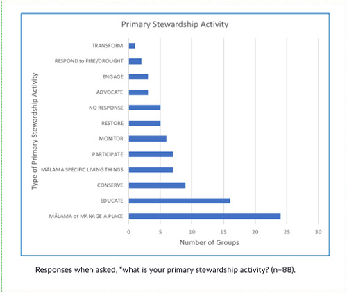
- Engaged in stewardship over a diverse range of sites for stewardship from mauka to makai. The top three are: forest, shoreline, nearshore reef.
- When asked, What do you want to achieve from your stewardship? about 1/3 of groups described a biocultural focus -- to improve integrated cultural, community, and environmental relationships.
Social Network Analysis
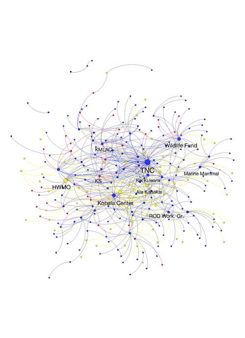
Node Legend:
Community/Civic Government Private
Social network analysis (SNA) measures can help us understand how stewardship groups are connected. The analysis above shows the groups that collaborate most regularly with other groups. The ten most central groups included: The Nature Conservancy, Hawaii Wildfire Management Organization, Kohala Center, Hawaii Wildlife Fund, Division of Forestry and Wildlife, Ala Kahakai, Waikoloa Dry Forest Initiative, Kai Kuleana Network, ROD Working Group, and the Ka‘ūpūlehu Marine Life Advisory Committee.
Community Product Ideas
-
Overlay a social network map onto a geospatial map to understand who is working where on water issues.
-
Strengthen capacity for systems approach through linking multiple projects that steward different parts of the same social-ecological system.
-
Data sharing platform to map out the ‘health’ of the land. Are we as small-scale restoration projects making a difference on a larger scale?
-
To learn more: https://bit.ly/stewmap
RESULTS/DISCUSSION
Group Characteristics
Most community/civic groups who participated in the survey:
- Have / have applied for 501c(3) status
- Have 5 or fewer full-time staff, 5 or fewer part-time staff, and 10 or fewer regular volunteers
- Annual budgets of >$10,000
- Engaged in stewardship over a diverse range of sites for stewardship from mauka to makai. The top three are: forest, shoreline, nearshore reef.
- When asked, What do you want to achieve from your stewardship? about 1/3 of groups described a biocultural focus -- to improve integrated cultural, community, and environmental relationships.
Social Network Analysis
Node Legend:
Community/Civic Government Private
Social network analysis (SNA) measures can help us understand how stewardship groups are connected. The analysis above shows the groups that collaborate most regularly with other groups. The ten most central groups included: The Nature Conservancy, Hawaii Wildfire Management Organization, Kohala Center, Hawaii Wildlife Fund, Division of Forestry and Wildlife, Ala Kahakai, Waikoloa Dry Forest Initiative, Kai Kuleana Network, ROD Working Group, and the Ka‘ūpūlehu Marine Life Advisory Committee.
Community Product Ideas
-
Overlay a social network map onto a geospatial map to understand who is working where on water issues.
-
Strengthen capacity for systems approach through linking multiple projects that steward different parts of the same social-ecological system.
-
Data sharing platform to map out the ‘health’ of the land. Are we as small-scale restoration projects making a difference on a larger scale?
-
To learn more: https://bit.ly/stewmap
A program of the U.S. Forest Service, STEW-MAP was developed in New York City in 2007 as a tool to better understand a region’s environmental stewardship resources and to support stewardship through an online database. STEW-MAP incorporates surveys, geospatial and Social Network Analysis (SNA), and interviews. After data is collected and analyzed, products are created to facilitate and support existing stewardship efforts.
Mālama ‘āina on Hawai‘i Island and O‘ahu
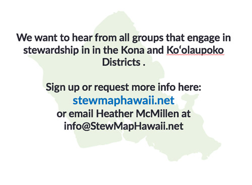
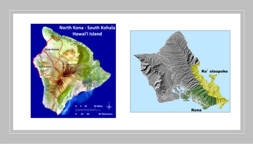
While STEW-MAP has been used in multiple cities in the United States and worldwide, STEW-MAP Hawai‘i represents the first non-urban iteration of STEW-MAP in a region with a strong indigenous presence, where cultural practice is often an important component of stewardship practice. The first STEW-MAP Project in Hawai‘i was launched in 2017 in North Kona and South Kohala, Hawai‘i Island. In 2018 we will begin surveying stewardship groups in Kona and Ko‘olaupoko, O‘ahu.
BACKGROUND
A program of the U.S. Forest Service, STEW-MAP was developed in New York City in 2007 as a tool to better understand a region’s environmental stewardship resources and to support stewardship through an online database. STEW-MAP incorporates surveys, geospatial and Social Network Analysis (SNA), and interviews. After data is collected and analyzed, products are created to facilitate and support existing stewardship efforts.
Mālama ‘āina on Hawai‘i Island and O‘ahu
While STEW-MAP has been used in multiple cities in the United States and worldwide, STEW-MAP Hawai‘i represents the first non-urban iteration of STEW-MAP in a region with a strong indigenous presence, where cultural practice is often an important component of stewardship practice. The first STEW-MAP Project in Hawai‘i was launched in 2017 in North Kona and South Kohala, Hawai‘i Island. In 2018 we will begin surveying stewardship groups in Kona and Ko‘olaupoko, O‘ahu.
STEW-MAP survey data will help us to better understand stewardship activities and identify the gaps and overlaps in stewardship to build community capacity and strengthen the system.
STEW-MAP provides a publicly available, online stewardship database and map of community organizations and other groups that work in stewardship. This database becomes a resource for community groups and partner agencies to:
•effectively communicate and collaborate with each other;
• to identify opportunities to support community-based efforts,
•and to enhance the capacity of the stewards of our communities.
We engage with local stewardship groups and community members to design and create products that can support stewardship efforts.
WHAT IS THE BENEFIT?
STEW-MAP survey data will help us to better understand stewardship activities and identify the gaps and overlaps in stewardship to build community capacity and strengthen the system.
STEW-MAP provides a publicly available, online stewardship database and map of community organizations and other groups that work in stewardship. This database becomes a resource for community groups and partner agencies to:
•effectively communicate and collaborate with each other;
• to identify opportunities to support community-based efforts,
•and to enhance the capacity of the stewards of our communities.
We engage with local stewardship groups and community members to design and create products that can support stewardship efforts.
Mahalo to Our Collaborators and Partners!
COLLABORATORS
Mahalo to Our Collaborators and Partners!
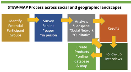
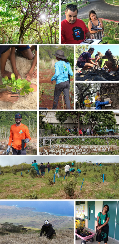
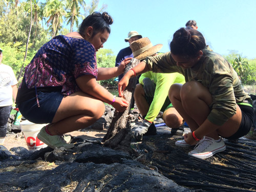
We used several methods to identify and contact local groups engaging in stewardship in North Kona and South Kohala, Hawai‘i Island. We worked with key informants to generate a list of potential stewards and followed up with groups listed as partners or collaborators by survey participants. We submitted press releases about the project to local newspapers, shared the project on social media, created a website, and provided information at community events.
Surveys were sent to groups who were identified or known as engaging in stewardship in the North Kona and South Kohala regions of Hawai‘i Island. Surveys were available online, by mail, and in-person. We administered our survey from July-October 2017, using the referral method to identify stewardship groups named by other groups. Here we share preliminary findings from the social network analysis, geospatial analysis, and qualitative analyses of survey data. These analyses are integrated to better understand the organizational characteristics of stewardship groups, how groups collaborate, and where they engage stewardship across the land and seascape of North Kona and South Kohala. In order to better understand social networks in the region, we asked participants about collaborators in five different types of networks: (i) regular collaborators; (ii) sources of knowledge, data, and expertise; (iii) Rapid ‘Ōhi‘a Death collaborators; and (iv) drought and/or fire management collaborators.
Our North Kona and South Kohala survey had a response rate of 38% (129 of 322 groups invited to take the survey did so), which indicates a robust data set. Currently, we are in the analysis and preliminary results phase. Follow-up interviews are in progress.
METHODS
We used several methods to identify and contact local groups engaging in stewardship in North Kona and South Kohala, Hawai‘i Island. We worked with key informants to generate a list of potential stewards and followed up with groups listed as partners or collaborators by survey participants. We submitted press releases about the project to local newspapers, shared the project on social media, created a website, and provided information at community events.
Surveys were sent to groups who were identified or known as engaging in stewardship in the North Kona and South Kohala regions of Hawai‘i Island. Surveys were available online, by mail, and in-person. We administered our survey from July-October 2017, using the referral method to identify stewardship groups named by other groups. Here we share preliminary findings from the social network analysis, geospatial analysis, and qualitative analyses of survey data. These analyses are integrated to better understand the organizational characteristics of stewardship groups, how groups collaborate, and where they engage stewardship across the land and seascape of North Kona and South Kohala. In order to better understand social networks in the region, we asked participants about collaborators in five different types of networks: (i) regular collaborators; (ii) sources of knowledge, data, and expertise; (iii) Rapid ‘Ōhi‘a Death collaborators; and (iv) drought and/or fire management collaborators.
Our North Kona and South Kohala survey had a response rate of 38% (129 of 322 groups invited to take the survey did so), which indicates a robust data set. Currently, we are in the analysis and preliminary results phase. Follow-up interviews are in progress.